Ejlinge
| Ejlinge | ||
|---|---|---|
| Map sketch | ||
| Waters | Kattegat | |
| Geographical location | 55 ° 36 ′ 0 ″ N , 10 ° 12 ′ 0 ″ E | |
|
|
||
| length | 995 m | |
| width | 235 m | |
| surface | 16.4 ha | |
| Residents | uninhabited | |
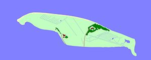
Ejlinge is since the late 1990s uninhabited Danish island in the Kattegat , only about 20 meters north of the island of Fyn ( dt. : Fyn ) at Æbelø located. Ejlinge belongs to the parish community ( Danish : Sogn ) Klinte Sogn, which until 1970 belonged to Harde Skam Herred in the Odense office , since then to the Bogense municipality in the former Fyns office , which became part of the Nordfyns municipality in the region as part of the municipal reform on January 1, 2007 Syddanmark has risen.
The area of the island is 14.3 hectares , according to other information 16.4 hectares. The length of the coastline is 2.27 km.
Individual evidence
- ↑ a b Google Earth
- ↑ Danmarks Statistics : Statistisk Aarbog 1920 - Table 3: Arealets Fordeling paa de forskellige større og minre Landsdele including Folkemængde og Befolkningstæthed on February 1, 1916, footnote 9 (Danish / French; PDF; 1.1 MB)

