
Elizabeth Islands
| Elizabeth Islands | ||
|---|---|---|
 |
||
| Waters | Buzzards Bay , Vineyard Sound | |
| archipelago | Outer Lands | |
| Geographical location | 41 ° 27 ′ N , 70 ° 49 ′ W | |
|
||
| Number of islands | 11 | |
| Main island | Cuttyhunk | |
| Total land area | 34.55 km² | |
| Residents | 86 (2000) | |
 |
||

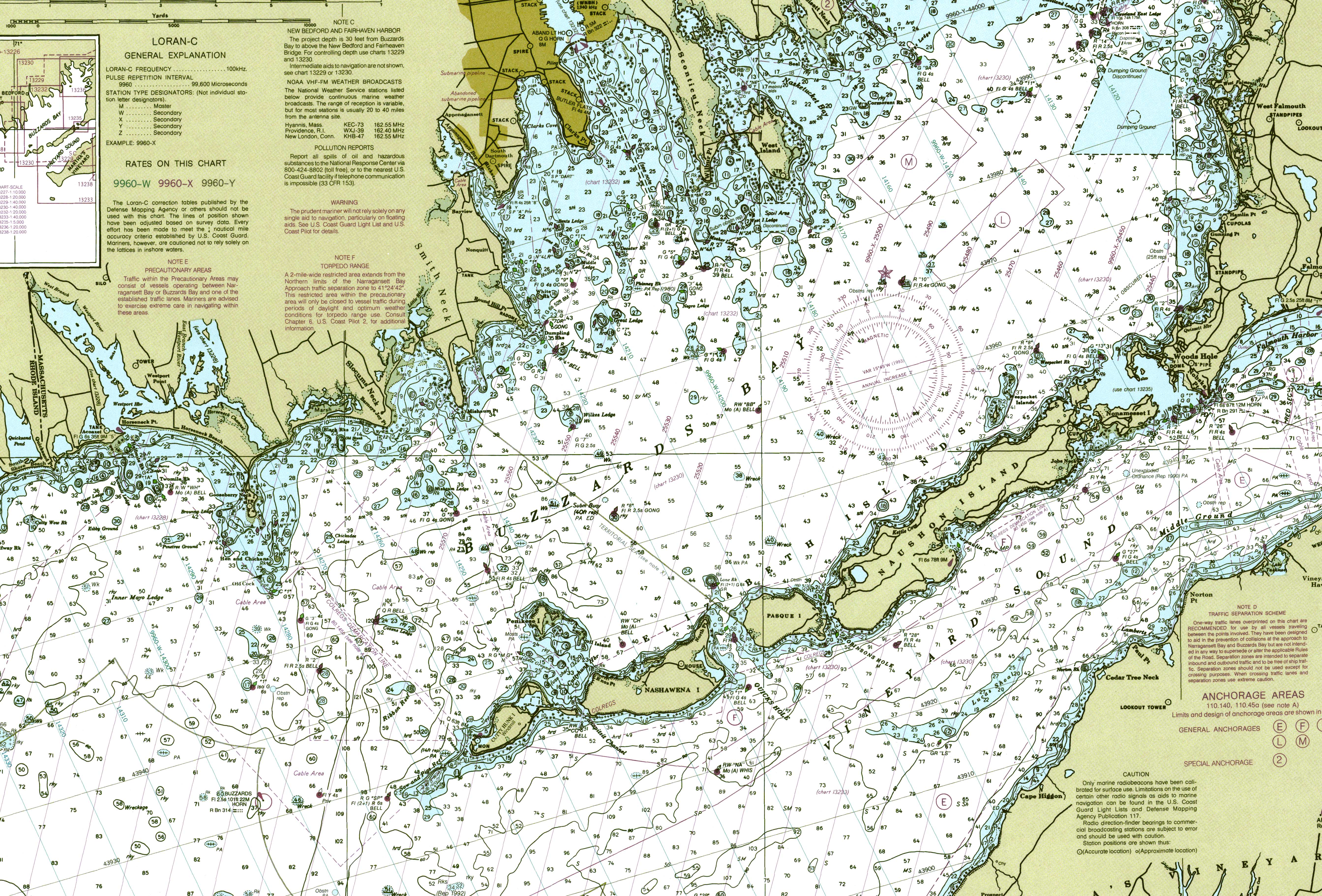
The Elizabeth Islands are a small chain of islands extending from the southern coast of Cape Cod ( Massachusetts in the United States to expand). They are located on outer Buzzards Bay north of Martha's Vineyard and form the parish of Gosnold in Dukes County . All of the Elizabeth Islands except Cuttyhunk and Penikese are privately owned by the Forbes family .
In 1641 Thomas Mayhew , Sir of Watertown bought the islands (with Nantucket and Martha's Vineyard) from William Alexander, the Earl of Sterling. Before the Province of Massachusetts Bay was founded , the islands were part of the now defunct Dukes County (New York) . The islands total land area is 34.55 km² and there was a permanent population of 86 people as per the 2000 census (of which 30 Naushon Island and 56 Cuttyhunk).
Named Islands
| No. | island | Area km² |
Coordinates | Remarks |
|---|---|---|---|---|
| 1 | Noname set | 1.398 | 41 ° 30 ′ 30 ″ N , 070 ° 41 ′ 15 ″ W. | easternmost island, closest island to the mainland at Falmouth |
| 2 | Cedar | |||
| 3 | Veckatimest Island | 0.0675 | 41 ° 30 ′ 27 " N , 070 ° 41 ′ 58" W. | |
| 4th | Monohansett | |||
| 5 | Bull | |||
| 6th | Uncatena | 0.492 | 41 ° 31'00 " N , 070 ° 42'20" W. | uninhabited (based on 2000 census) |
| 7th | Bachelor | |||
| 8th | Naushon | 19,180 | 41 ° 29'00 " N , 070 ° 46'00" W. | 30 inhabitants (2000); 12.3 km long; belongs to the Naushon Island Trust of the Forbes Families; not public |
| 9 | Weepecket Islands | 0.051 | 41 ° 31'00 " N , 070 ° 44'11" W. | uninhabited; three small, publicly accessible islands north of central Naushon; owned by the Forbes family |
| 10 | Pasque | 3,450 | 41 ° 27'00 " N , 070 ° 49'35" W. | uninhabited; 2.4 km long; possessed by part of the Forbes family and covered in poison ivy ; a shallow tidal stream makes its way through the island |
| 11 | Nashawena | 7.076 | 41 ° 25 ′ 45 ″ N , 070 ° 52 ′ 30 ″ W. | inhabited; 4.8 km long; owned by another part of the Forbes family; grazing cattle |
| 12 | Gull Island | |||
| 13 | Penises | 0.182 | 41 ° 27'05 " N , 070 ° 55'21" W. | uninhabited; about 0.5 miles north of Nashawena and Cuttyhunk; Location of a reform school |
| 14th | Cuttyhunk | 2,347 | 41 ° 25'08 " N , 070 ° 56'02" W. | 56 inhabitants (2000); Main island; westernmost island; Home of the community residents of Gosnold; most of it is open to the public |
| Elizabeth Islands | 34,550 | 41 ° 27 ′ 00.0 ″ N , 070 ° 49 ′ 00.0 ″ W. | ||
Named canals and ports
Canals with strong tidal currents, known here as holes , separate the islands from each other and from the mainland. The currents reach speeds of up to 6 knots (11 km / h) due to varying sizes and fill rates of the Vineyard Sound in the southeast and Buzzard's Bay in the northwest. At high tide, the water flows from Buzzards Bay to Vineyard Sound. Between ebb and flow the water stops and turns around and fills the bay at low tide.
Listed from Falmouth are the named channels:
- Woods Hole separates the mainland from Nonamesset Island
- Robinson Hole between Naushon Island and Pasque Island
- Quick's Hole between Pasque Island and Nashawena Island
- Canapitsit Channel between Nashawena Island and Cuttyhunk
- Cuttyhunk Harbor is protected by Nashawena Island to the east, Cuttyhunk to the west, and Penikese to the north.
Web links
- Cuttyhunk Historical Society, The Elizabeth Islands Museum. The proposal of the Cuttyhunk Historical Society is to preserve the traditions, records and history of the Elizabeth Islands for benefit to present and future generations.
- Nautical chart