Ellenserdammer low
| Ellenserdammer low | ||
|
The deep in the quarry pond area |
||
| Data | ||
| location |
|
|
| Drain over | Dangaster Deep → Jade Bay → North Sea | |
| source | Confluence of Friedeburger Tief and Neustädter Tief 53 ° 27 ′ 37 ″ N , 8 ° 1 ′ 0 ″ E |
|
| muzzle | At the Petershörn pumping station in the Dangaster Tief Coordinates: 53 ° 26 '14 " N , 8 ° 5' 32" E 53 ° 26 '14 " N , 8 ° 5' 32" E
|
|
| length | 7 km | |
| Right tributaries | Steinhauser Tief | |
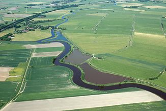
The Ellenserdammer Tief is a body of water in the district of Friesland , in northwest Lower Saxony .
The low is created by the confluence of the Friedeburg low and the Neustadt low, about 2.7 km southeast of Neustadtgödens . It initially runs in a south-easterly direction, crossing under the A 29 , the L 815, the Oldenburg – Wilhelmshaven railway line and Grodenstrasse near Ellenserdammersiel . Then the low takes a curved eastern course, which was created between 1993 and 2001 by the mining of clay . This and any quarry belonged from 2011 to the conservation area "marshes on Jade Bay-West". Since February 2019, the Ellenserdammer Tief and the quarry ponds have been in the " Teichfledermausgewässer " landscape protection area , which was designated to safeguard the FFH area "Teichfledermaus-Habitat in the Wilhelmshaven area".

After a length of 7 km, the Ellenserdammer Tief flows into the Dangaster Tief at the Petershörn pumping station .
Individual evidence
- ↑ Viewing platform on the Ellenserdammer Tief. (No longer available online.) Archived from the original on September 26, 2016 ; Retrieved September 26, 2016 . Info: The archive link was inserted automatically and has not yet been checked. Please check the original and archive link according to the instructions and then remove this notice.
