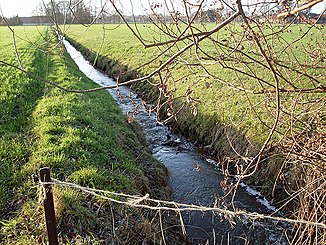
Ellerbrockgraben
|
Ellerbrockgraben ( Wennerbach ) |
||
|
The Ellerbrockgraben as the border between Halle and Steinhagen |
||
| Data | ||
| Water code | DE : 313692 | |
| location | North Rhine-Westphalia , Germany | |
| River system | Ems | |
| Drain over | Rhedaer Bach → Ems → North Sea | |
| source | In the peasantry Sandforth 52 ° 1 ′ 23 ″ N , 8 ° 20 ′ 33 ″ E |
|
| Source height | 88 m above sea level NN | |
| muzzle | At Kölkebeck in the Rhedaer Bach Coordinates: 52 ° 0 '33 " N , 8 ° 17' 25" E 52 ° 0 '33 " N , 8 ° 17' 25" E |
|
| Mouth height | approx. 74 m above sea level NN | |
| Height difference | approx. 14 m | |
| Bottom slope | approx. 3.3 ‰ | |
| length | 4.2 km | |
| Communities | Halle (Westphalia) , Steinhagen | |
The Ellerbrockgraben , alternatively also known as Wennerbach , is an orographically left tributary of the Rhedaer Bach in North Rhine-Westphalia , Germany . It has a length of 4.2 km.
River course
The Ellerbrockgraben is created between the village of Brockhagen, which belongs to Steinhagen, and the Hall district of Bokel , not far from the Sandforther See. It flows off in a south-westerly direction and drains the meadows of the farming communities Sandforth and Kölkebeck on its route, which runs exclusively through rural areas . The Ellerbrockgraben also forms the border between the city of Halle and the municipality of Steinhagen.
At Kölkebeck, the water, whose name is derived from the Low German word for Erlenbruch , finally flows into the Rhedaer Bach, which flows from the north and is divided into two arms in this area . The left arm to which the Ellerbrockgraben flows is also known as the Mühlenbach . The Rhedaer Bach finally flows into the Ems at Harsewinkel .
The Ellerbrockgraben overcomes a height difference of 14 meters during its flow path, resulting in a mean bed gradient of 3.3 ‰.
Individual evidence
- ↑ a b c German basic map 1: 5000
- ↑ Water directory of the State Office for Nature, Environment and Consumer Protection NRW (PDF; 1.1 MB)
