Elsengraben (Marzahn-Hohenschönhausener Grenzgraben)
| Elsengraben | ||
|
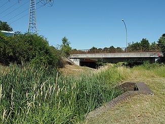
Elsengraben runs under the Brücker Boxberger Straße |
||
| Data | ||
| location | Berlin , Germany | |
| River system | Elbe | |
| Drain over | Elsengraben (Marzahn-Hohenschönhausener Grenzgraben) → Spree → Havel → Elbe → North Sea | |
| source |
Berlin-Wartenberg 52 ° 33 ′ 24 ″ N , 13 ° 30 ′ 52 ″ E |
|
| muzzle | Papenpfuhlbecken Coordinates: 52 ° 32 '25 " N , 13 ° 31' 38" E 52 ° 32 '25 " N , 13 ° 31' 38" E
|
|
| length | 2.5 km | |
| Big cities | Berlin | |
Die Wuhle (green brands) in Ahrensfelde and Berlin |
The Elsengraben ( ) is a water collection ditch in the Berlin district of Lichtenberg . It has a total length of about 2.5 kilometers and crosses the districts of Wartenberg and Alt-Hohenschönhausen .
course
The moat begins in a spring meadow area in the Lichtenberg district at the level of Wartenberger Straße and the embankment area in Kietzer Weg. Then it runs east parallel to Josef-Höhn-Straße, to Marzahner Straße and to Wassergrundstraße southwards. It ends in the Papenpfuhl basin , which is located in a curve in the track system between Landsberger Allee and Bürknersfelder Straße. The basin is drained through the Marzahn-Hohenschönhausener Grenzgraben towards Rummelsburger See . In its course, the Elsengraben is spanned by several bridges , including a small structure on Gottliebstraße, Christiansteg between Edgarstraße and Josef-Höhn-Straße and the bridge at the confluence with the basin. In other places, the Elsengraben is routed through pipes under the streets, for example under Gehrenseestrasse, Bennostrasse and the eastward continuation of Bürknersfelder Strasse. A moat was already marked on Berlin city maps in the middle of the 20th century, but it has no name. It begins north in allotment gardens / Mühlengrund settlement. A collecting basin, however, is not yet available. The end is on Ferdinand-Schulze-Strasse, the rest of which was probably piped up.
Individual evidence
- ↑ estimated from map material
- ↑ Elsengraben on Google maps
- ↑ Waters map - Waters directory - viewed via the FIS broker of the Senate Department for Urban Development and Environment on October 6, 2013 (click on the coordinates and select "FIS Broker" on the GeoHack page that then appears)
- ↑ Elsengraben route on a city map from 1946 ( page no longer available , search in web archives ) Info: The link was automatically marked as defective. Please check the link according to the instructions and then remove this notice.

