Epukiro (river)
| Epukiro | ||
|
Epukiro (center right) |
||
| Data | ||
| location |
Omaheke , Namibia's North West District , Botswana |
|
| River system | Eiseb-Epukiro | |
| source |
Omaheke 21 ° 43 ′ 34 ″ S , 18 ° 19 ′ 24 ″ E |
|
| muzzle |
Okavango Delta
|
|
| Catchment area | 19,426 km² | |
| Navigable | No | |
| Rivier (dry river) | ||
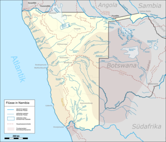
The Epukiro is an Omuramba in the central east of Namibia . Among other things, the Epukiro settlement of the same name is due to him . Together with the Eiseb it forms the Eiseb trench as an aquifer . It rises in the constituency of Epukiro and flows into the western foothills of the Okavango Delta . As a dry river , it carries water very irregularly.
Its catchment area covers an area of 19,425.793 square kilometers (Eiseb 10,671.777 km²), according to other sources, however, including the Eiseb, a maximum of 10,665 km².
literature
- Investigation of Groundwater Resources and Airborne-Geophysical Investigation of Selected Mineral Targets in Namibia - Groundwater Investigations in the Eiseb Graben. Department of Water Affairs / Federal Institute for Geosciences and Natural Resources, Windhoek / Hannover, December 2004, edition IV.GW.3.1. ( PDF )
- Eiseb-Epukiro River Basin. Integrated Water Resources Management, Ministry of Agriculture, Water and Forestry. ( PDF )
