Erciyes Dağı
| Erciyes Dağı | ||
|---|---|---|
| height | 3916 m | |
| location | Kayseri Province , Turkey | |
| Coordinates | 38 ° 31 '50 " N , 35 ° 27' 0" E | |
|
|
||
| Type | extinct stratovolcano | |
| Last eruption | 6880 BC Chr. | |
| First ascent | 1837 by William John Hamilton | |
|
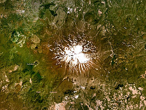
Satellite image of the Erciyes Dağı |
||
|
Erciyes Dağı in 3D (based on a TERRA ASTER elevation model). |
||
Mount Erciyes (Turkish: Erciyes Dağı ) is a 3917 m or 3916 m high dormant volcano in Turkey . It is located 25 km south of Kayseri in Cappadocia . The mountain is a symbol of Kayseri. It towers over the city, which is about 1000 m high, by 2900 m. In this dry area, the Erciyes provides more than 1000 km² of fertile land. At the foot of the mountain you can meet the tents of semi-nomads .
The ancient name of Erciyes Dağı was Argaios ( Greek Ἀργαῖος , or Ἀργαῖον ὄρος Argaion oros , Latin Argaeus Mons ). The name is a modification of the Hittite name Ḫarki ("the white one"). During the Hittite purulliya festival , Ḫarki was told to stay in place alongside other mountains.
The geographer Strabo reported in his description of the area around Caesarea ( Kayseri ) of plains that were littered with fire pits, where at night the flames broke out of the ground. According to Strabo, during his time (54 BC to 19 AD) there were sulphurous hot water vapors on the Erciyes Dağı. The mountain was occasionally depicted on the reverse of coins for the Greek-minted provinces even in Roman times.
The famous and unique tufa landscapes of Göreme and, further on, Cappadocia with their typical rock cones - called " fairy chimneys " (Turkish peri bacaları ) by the locals - are mainly the result of the eruptions of the Erciyes and partly also of the Hasan Dağı (near Aksaray ).
The first ascent was made by William John Hamilton in 1837.
However, the ruins of a church on the summit prove the repeated ascent in Byzantine times. The mountain is relatively easy to climb from the east. Only in the area of the summit ridge - also covered in snow in midsummer - rope safety is recommended for short sections of the route .
The Erciyes is an important winter sport and ski area .
literature
- Bahattin Ayranci: On the petrology and geology of the Erciyes volcano area near Kayseri in Central Anatolia, Turkey. Dissertation, Würzburg 1991.
- Gerhart Bartsch: The area of the Erciyes Dağı and the city of Kayseri in Central Anatolia. With 7 map boards, 8 pictures and 4 text illustrations. In: Erich Obst, Gerhart Bartsch, Hugo Weigold (eds.): Yearbook of the Geographical Society of Hanover for 1934 and 1935. Helwing, Hanover 1935, pp. 87–202.
- Oğuz Güler: Antik çağ ikonografisinde Erciyes. Contains : İhsan Ketin: Erciyes Dağı volkan topluluğunun jeoljik evrimi. Arkeoloji ve Sanat Yayınları, İstanbul 1995, ISBN 975-7538-27-2 .
- Harald Kürschner: Vegetation and flora of the high regions of Aladaǧları and Erciyes Daǧı, Turkey. Reichert, Wiesbaden 1982, ISBN 3-88226-126-9 .
- Peter Weiss: Argaios / Erciyes Dağı - Sacred Mountain of Cappadocia. Monuments and Iconography. In: Yearbook for Numismatics and Monetary History 35 (1985), pp. 21–48.
Web links
- Erciyes Dağı in the Global Volcanism Program of the Smithsonian Institution (English)
Individual evidence
- ↑ Erciyes Dagi on Peakbagger.com
- ^ A b Wolf-Dieter Hütteroth / Volker Höhfeld: Turkey . Wissenschaftliche Buchgesellschaft Darmstadt 2002, p. 43 ISBN 3-534-13712-4
- ↑ Karl Strobel: Argaios (2) In: Der Neue Pauly . Stuttgart 1996ff
- ↑ Volkert Haas : History of the Hittite Religion ; BTE 1.15. Brill 1994, ISBN 978-9-004-09799-5 . P. 726
- ↑ Hild / Restle TIB 2 Cappadocia Vienna 1985


