Goreme
| Goreme | ||||
|
||||
| Basic data | ||||
|---|---|---|---|---|
| Province (il) : | Nevşehir | |||
| District ( ilçe ) : | Nevşehir | |||
| Coordinates : | 38 ° 39 ' N , 34 ° 50' E | |||
| Height : | 1100 m | |||
| Residents : | 2,154 (2018) | |||
| Telephone code : | (+90) 384 | |||
| Postal code : | 50 180 | |||
| License plate : | 50 | |||
| Structure and administration (as of 2019) | ||||
| Structure : | 2 malls | |||
| Mayor : | Ömer Eren ( MHP ) | |||
| Postal address : | Aydınlı Orta Mah. Adnan Menderes Cd. No 50180 Göreme / Nevşehir |
|||
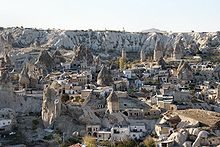
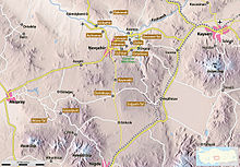
Göreme is a municipality in Cappadocia in the central district of the Turkish province of Nevşehir . The place was called Matiana in Byzantine times and was renamed Göreme in 1928 , a Turkic form of the old name Korama .
The place is the center of the Göreme National Park , which together with other rock monuments of Cappadocia has been a UNESCO World Heritage Site since 1985 . The landscape is dominated by Goreme by distinctive tufa formations that are partially hollowed out, the so-called fairy chimneys (peri bacaları English. Fairy chimney, Turk.), For which this region is mainly tourist known.
Emergence
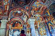
Tufa of varying hardness forms the basis for this landscape: volcanic eruptions and watercourses formed the typical structures over the course of several million years. The first Christians used them to lead a devout life in seclusion, but above all as a hiding place from their enemies (Persians, Romans, Arabs, Mongols). They not only built churches and chapels that were worked into the rock, but entire residential complexes for several thousand people. In some cases up to ten floors deep, with facilities such as kitchens, warehouses, bedrooms and even animal stalls and morgues including ventilation shafts, they made living conditions reasonably comfortable.
Living in tuff offered a further advantage with regard to the weather: it keeps you cool in summer, but does not cool down as much in winter. The corridors could be blocked with large millstone-like stones if necessary. Up to 100 systems are believed to be connected to one another. Derinkuyu is the largest of the touristic facilities and housed (probably) around 10,000 people.
Historical dates
- 4th century: first residents and church buildings
- around 1100: Yilanli Church, Barbara Church
- c. 1200: Çarikli Church
- 1923/24: Göreme was left by the last inhabitants
- 1957: a church of St. John the Baptist was discovered
Web links
- Entry on the UNESCO World Heritage Center website ( English and French ).
- Chih-Hsing Shen, M. Eray Oezkan: Göreme (student project at the University of the Arts, Berlin, SS 1996)
- Cappadocia Academy - Göreme regional and travel information
- Photos and descriptions of the sights of Goreme
- Goreme hiking map
- Mappadocia
- Virtual tour of Goreme
- Side of the Goreme Tourism Society (English)
Individual evidence
- ↑ Türkiye Nüfusu İl ilçe Mahalle Köy Nüfusları , accessed on July 12, 2019
- ^ Anatolic index


