
Amed city walls
| Diyarbakır Fortress | |
|---|---|
|
UNESCO world heritage |
|

|
|
| Amed city walls |
|
| National territory: |
|
| Type: | Culture |
| Criteria : | ii, iii, iv |
| Reference No .: | 1518 |
| UNESCO region : | Europe and North America |
| History of enrollment | |
| Enrollment: | 2015 ( session 39 ) |
The Roman city wall of Amed is a completely preserved city wall over five kilometers long around the old town of Amed in the province of Diyarbakır in today's Turkey . The fortification was included in the UNESCO list of world cultural heritage in 2015 .
history


In the year 349 the Roman Emperor Constantius II had the walls and castle of the city renewed and massively expanded, since the previously rather insignificant place was now to become a main fortress on the hard-fought border with Persia . This is how the walls got their current appearance. Since then, the walls have been reinforced several times, but their core is still predominantly late antique.
Outside these walls there was a rampart that was demolished in 1232 by the Ayyubid Al-Kamil . Part of the northern wall was also demolished in the 1930s.
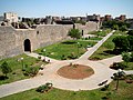
description
Amed has one of the largest and best-preserved ancient fortifications in the world. The wall is 5.7 kilometers long, ten to twelve meters high and three to five meters thick. The system is divided into an inner and an outer section. The dark basalt , of which most of the fortification is made, gives the old town an air of defiant inaccessibility. In some places stairs lead to the wall and you can walk almost completely. It has 82 towers and four main gates. The gates point in the four cardinal directions:
- Dağ Kapısı (Mountain Gate) or Harput Kapısı in the north
- Urfa Kapısı (gateway to Urfa ) or Rum Kapısı in the west
- Mardin Kapısı (gateway to Mardin ) or Tel Kapısı in the south
- Yeni Kapı (New Gate), Dicle Kapısı (Tigristor) or Su Kapısı (Water Gate) in the east.
The citadel is located in the northeast part of the outer wall. The castle is separated from the outer wall by walls. It has 16 towers and four gates, two of which - Fetih Kapısı and Oğrun Kapısı - open to the outside and the other two - Saray Kapısı and Küpeli Kapısı - open to the city. Within these walls is a hill with the district of Viran Tepe . Sultan Suleyman I enlarged the complex.

The city walls of Amed

View of parts of the city wall from Kizi Burçu

Mardin Kapısı (South Gate) 1990
City wall in the west

Dağ Kapısı or mountain gate in the north of the complex

View from the city wall to the Hevsel Gardens and the Tigris

Hevsel Gardens


Current situation
In the last few decades the city has grown rapidly and the walls were endangered by buildings that were directly on it. Therefore, the city administration cleared the area on the walls of buildings and created green spaces on the inside of the wall.
The walls and especially the many towers, which are also often misused as toilets, are currently very unsafe, especially at night; it is therefore advisable not to visit the walls after dark.
In 2011 the film Mes - Lauf! turned.
The western part of the city wall was damaged from December 2015 in the course of the Turkish offensive against the PKK to the detriment of the Kurdish regions. Zülfü Livaneli , the voluntary Turkish UNESCO ambassador, resigned from his position in May 2016 in protest because UNESCO was not doing anything to prevent the destruction of the cultural sites.
Individual evidence
- ↑ Diyarbakir Fortress and Hevsel Gardens Cultural Landscape. UNESCO
- ↑ https://www.heise.de/tp/features/Zerstoertes-Diyarbakir-3380209.html
- ↑ UNESCO vows 'commitment' to protect Diyarbakır's Sur after Livaneli criticism. Daily News, June 3, 2016
- ↑ Elke Dangeleit: Destroyed Diyarbakir. The city administration complains about expropriations by the Turkish government. Telepolis, June 19, 2016

Heritage: Historic Areas of Istanbul (1985) | Divriği Great Mosque and Hospital (1985) | Ḫattuša - capital of the Hittites (including the Yazılıkaya rock sanctuary ) (1986) | Nemrut Dağı (1987) | Xanthos - Letoon (1988) | Safranbolu Old Town (1994) | Archaeological Site of Troy (1998) | Selimiye Mosque in Edirne (2011) | Neolithic site of Çatalhöyük (2012) | Bursa and Cumalıkızık: the cradle of the Ottoman Empire (2014) | Pergamon and its cultural landscape (2014) | Diyarbakır Fortress and Hevsel Gardens Cultural Landscape (2015) | Ephesus (2015) | Archaeological site of Ani (2016) | Aphrodisias (2017) | Göbekli Tepe (2018)
Cultural / natural heritage: Göreme National Park and the rock structures of Cappadocia (1985) | Ancient City of Hierapolis - Pamukkale (1988)