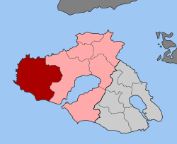
Eresos-Andissa
|
Municipality of Eresos-Andissa Δημοτική Ενότητα Ερεσού-Αντίσσης (Ερεσός-Άντισσα) |
||
|---|---|---|
|
|
||
| Basic data | ||
| State : |
|
|
| Region : |
North Aegean
|
|
| Regional District : | Lesbos | |
| Municipality : | Dytiki Lesvos | |
| Geographic coordinates : | 39 ° 12 ' N , 26 ° 1' E | |
| Height above d. M .: | 0-589 m Aegean – Vigla (Ordymnos mountainous region) |
|
| Area : | 290.947 km² | |
| Residents : | 5,269 (2011) | |
| Population density : | 18.1 inhabitants / km² | |
| Code No .: | 530105 | |
| Structure: |
3 city districts 4 local communities |
|
| Located in the municipality of Dytiki Lesvos and in the regional district of Lesvos | ||
Eresos-Andissa ( Greek Ερεσός-Άντισσα ) is a municipality in the municipality of Dytiki Lesvos on the Greek island of Lesbos . The municipality with the largest area of the municipality extends in the far west of the island over an area of 290.947 km². It has 5269 inhabitants (2011) and is divided into three boroughs and four local communities. The municipality of Kalloni borders in the east .
Administrative division
The municipality of Eresos-Andissa emerged in 2011 from the municipality of the same name, which was founded on the occasion of the territorial reform in 1997 from the former municipality of Eresos and six other rural communities. Since the correction of the administrative reform in 2019, the municipality of Eresos-Andissa belongs to the municipality of Dytiki Lesvos .
| District local community |
Greek name | code | Area (km²) | 2001 residents | Residents 2011 | Villages and settlements |
|---|---|---|---|---|---|---|
| Eresos | Δημοτική Κοινότητα Ερεσού | 53010501 | 65,609 | 1581 | 1611 | Eresos, Skala Eresou , Chliara, Christos, Psinia |
| Andissa | Δημοτική Κοινότητα Αντίσσης | 53010502 | 77.454 | 1340 | 1205 | Andissa, Gavvathas, Kambos, Lygeri, Moni Agiou Ioannou Theologou, Pedino, Pochis, Tzithra |
| Vatoussa | Τοπική Κοινότητα Βατούσσης | 53010503 | 22.881 | 570 | 598 | Vatoussa, Revma |
| Mesotopus | Δημοτική Κοινότητα Μεσοτόπου | 53010504 | 38,401 | 1039 | 904 | Mesotopos, Podaras, Tavari, Chrousos |
| Pterounda | Τοπική Κοινότητα Πτερούντος | 53010505 | 19.043 | 150 | 146 | Pterounda |
| Sigri | Τοπική Κοινότητα Σιγρίου | 53010506 | 39.708 | 402 | 333 | Sigri, Megalonisi |
| Chidira | Τοπική Κοινότητα Χιδήρων | 53010507 | 27.851 | 448 | 472 | Chidira |
| total | 530105 | 290.947 | 5530 | 5269 | ||
Individual evidence
- ↑ Results of the 2011 census, Greek Statistical Office (ΕΛ.ΣΤΑΤ) ( Memento from June 27, 2015 in the Internet Archive ) (Excel document, 2.6 MB)
- ↑ Κεντρική Ένωση Δήμων και Κοινοτήτων Ελλάδας, Ελληνική Εταιρία Τοπικής Ανάπτυξης και Αυτοδιοίκησης (ed.): Sanakirja Διοικητικών Μεταβολών των Δή microns ων και Κοινοτήτων (1912-2001) . 1 (Τόμος Α, α – κ). Athens 2002, ISBN 960-7509-47-1 , pp. 339 f .

