
Kalloni
|
Kalloni municipality Δημοτική Ενότητα Καλλονής (Καλλονή) |
|||
|---|---|---|---|
|
|||
| Basic data | |||
| State : |
|
||
| Region : |
North Aegean
|
||
| Regional District : | Lesbos | ||
| Municipality : | Dytiki Lesvos | ||
| Geographic coordinates : | 39 ° 14 ' N , 26 ° 12' E | ||
| Height above d. M .: | 0–100–699 m Aegean – Kalloni – Profitis Ilias |
||
| Area : | 241.946 km² | ||
| Residents : | 8,504 (2011) | ||
| Population density : | 35.1 inhabitants / km² | ||
| Code No .: | 530107 | ||
| Structure: |
2 city districts 7 local communities |
||
| Located in the municipality of Dytiki Lesvos and in the regional district of Lesvos | |||
 |
|||

Kalloni ( Greek Καλλονή ( f. Sg. )) Is a municipality in the municipality of Dytiki Lesvos on the Greek island of Lesbos . In terms of area and population, Kalloni is the second largest municipality in the municipality. The small town of the same name with 1978 inhabitants (2011) is also the administrative seat of the municipality of Dytiki Lesvos.
geography
The municipality is located on the northwest side of the Gulf of Kalloni (Κόλπος Καλλονής) and extends to the north coast of the island. Neighboring parishes are Eresos-Andissa in the west, Petra in the north and Agia Paraskevi in the east . The place Kalloni lies in a fertile plain of 100 km² about 3 km inland from the gulf.
Administrative division
Kalloni was founded as an independent rural community (Κοινότητα Καλλονή) in 1918. Through several incorporations, the community area was constantly enlarged and in 1994 received the status of a township (Δήμος Καλλονής). Incorporation on the occasion of the territorial reform in 1997 enlarged the municipal area again. Since the administrative reform in 2010 , Kalloni has formed a municipality in the newly created municipality of Lesvos (Δήμος Λέσβου). The small town of Kalloni, which is a commercial center of the island due to its central location. Since the correction of the administrative reform in 2019, Kalloni has belonged to the municipality of Dytiki Lesvos .
| District local community |
Greek name | code | Area (km²) | 2001 residents | Residents 2011 | Villages and settlements |
|---|---|---|---|---|---|---|
| Kalloni | Δημοτική Κοινότητα Καλλονής | 53010701 | 36,585 | 2027 | 2171 | Kalloni, Petsofas, Moni Panagia Myrsiniotissis Limonos |
| Agra | Δημοτική Κοινότητα Άγρας | 53010702 | 60.256 | 1030 | 1013 | Agra, Apothikes, Agios Georgios |
| Anemotia | Τοπική Κοινότητα Ανεμότιας | 53010703 | 24.306 | 534 | 449 | Anemotia |
| Arisvi | Τοπική Κοινότητα Αρίσβης | 53010704 | 2.575 | 465 | 700 | Arisvi |
| Dafia | Τοπική Κοινότητα Δαφίων | 53010705 | 10.428 | 869 | 1009 | Dafia, Moni Limonos |
| Ceramic | Τοπική Κοινότητα Κεραμίου | 53010706 | 3,500 | 1000 | 1054 | Kerami, Skala Kallonis |
| Parakila | Τοπική Κοινότητα Παρακοίλων | 53010707 | 35.903 | 926 | 818 | Parakila |
| Scalochori | Τοπική Κοινότητα Σκαλοχωρίου | 53010708 | 46.162 | 666 | 605 | Skalochori, Archea Andissa, Kalo Limani, Balini |
| Filia | Τοπική Κοινότητα Φίλιας | 53010709 | 22.231 | 677 | 685 | Filia, Kechrada |
| total | 530107 | 241,946 | 8194 | 8504 | ||
Attractions
A few kilometers west of Agra, there are two hulls of windmills on either side of the road. On the outskirts of Parakila are the remains of a decaying Turkish bathhouse. A little south of the village are the remains of an old bridge. A few kilometers further in the direction of Agra there is a well-preserved minaret from the time of the Turkish occupation on the south side of the road. The fishing village of Skala Kallonis has tourist importance due to its beautiful beaches. The anchovy festival takes place in summer. The anchovies from the bay of Kalloni are traded worldwide. To the west of the village is a marshland rich in turtles, snakes and frogs. The Limonos men's monastery has several chapels and a well-tended inner courtyard with peacocks.

Windmills near Agra

Potamia, brook near Skala Kallonis

Turkish bath house

Remnants of an old bridge

minaret


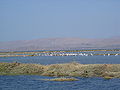
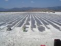
Salt pans
To the southeast of Kalloni there are salt pans , which are still used today to extract salt from seawater by evaporation. The 10 to 12 meter high white salt mountains are visible from afar around the bay. The outer salt flats are rich in exotic birds such as flamingos , white herons , black storks . There is a bird watching tower for the public on the way there.
Flamingos on the salt lagoon
Leftovers after ingesting the salt

Soaking up the salt

A salt crystal


traffic
Kalloni is connected to Mytilene by the national road 36 . The distance is about 39 km.
Sports
The AEK Kalloni played for three years, from 2013 to 2016 as the first football club from Lesbos in the Super League , the first Greek league.
Individual evidence
- ↑ 212 Lesbos, 1: 70,000 (map) . Road Editions, ISBN 978-960-8481-92-3 .
- ↑ Results of the 2011 census, Greek Statistical Office (ΕΛ.ΣΤΑΤ) ( Memento from June 27, 2015 in the Internet Archive ) (Excel document, 2.6 MB)
- ↑ Κεντρική Ένωση Δήμων και Κοινοτήτων Ελλάδας, Ελληνική Εταιρία Τοπικής Ανάπτυξης και Αυτοδιοίκησης (ed.): Sanakirja Διοικητικών Μεταβολών των Δή microns ων και Κοινοτήτων (1912-2001) . 1 (Τόμος Α, α – κ). Athens 2002, ISBN 960-7509-47-1 , pp. 413 f .