Explorer 6
| Explorer 6 | |
|---|---|

|
|
| Type: | Research satellite |
| Country: |
|
| Operator: |
|
| COSPAR-ID : | 1959-004A (1959-Delta-1) |
| Mission dates | |
| Dimensions: | 64.4 kg |
| Begin: | August 7, 1959, 14:24 UTC |
| Starting place: | Cape Canaveral AFS LC 17-A |
| Launcher: | Thor-Able III 134 |
| Flight duration: | almost 2 years |
| Status: | Inoperative from October 6, 1959, burned up on June 30, 1961 |
| Orbit data | |
| Rotation time : | 765 min |
| Orbit inclination : | 47 ° |
| Apogee height : | 42400 km |
| Perigee height : | 245 km |
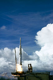
Explorer 6 was an American satellite that was launched on August 7, 1959.
Structure and Mission
The small, spherical satellite was designed as part of the Explorer program to study geomagnetism and the propagation of radio waves in the higher atmosphere , among other things . A camera on board was also used for the first time to take pictures of the earth from space. Explorer 6 was placed in a very elliptical orbit. The satellite was spin stabilized and spun at 2.8 revolutions per second. Four solar cells , which were fixed around the equator of the satellite, were used to recharge the batteries in space, of which only three unfolded completely. The last contact with the satellite was made on October 6, 1959.
Web links
Commons : Explorer 6 - collection of pictures, videos and audio files
Individual evidence
- ↑ a b Explorer 6 in the NSSDCA Master Catalog , accessed on August 1, 2014 (English).
- ↑ Explorer in the Encyclopedia Astronautica , accessed October 1, 2012 (English).
- ↑ 50 years of Earth Observation. ESA, October 3, 2007, accessed July 10, 2009 .


