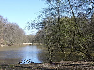
Försterwiesenweiher
| Försterwiesenweiher | ||
|---|---|---|

|
||
|
The Försterwiesenweiher in spring, view from the west |
||
| Geographical location | Frankfurt city forest | |
| Data | ||
| Coordinates | 50 ° 4 '0.1 " N , 8 ° 42' 16.9" E | |
|
|
||
| surface | 0.63 ha | |
The Försterwiesenweiher is a pond in the Hessian city of Frankfurt am Main . The still water with a water surface of 6,300 m² is located in the southern Main district of Sachsenhausen in the Frankfurt city forest . The pond was artificially created in 1958. It absorbs part of the rainwater that flows from the 500 meters south-running route of the federal motorway 3 .
location
The Försterwiesenweiher lies on the edge of an area designated as a fauna and flora habitat in the extreme southeast of Sachsenhausen and the eastern part of the city forest known as the Oberwald . The area belongs to the southern section of the Frankfurt green belt . In addition to the rainwater, the pond is fed by the water from two ditches that flow into it from the northeast. A few meters to the south-east is the Kesselbruchweiher pond, which was created in the late 1960s .
history
The name of the pond refers to the Försterwiese adjoining to the east , a piece of land on which the forester responsible for this part of the forest was allowed to keep two cows in the 18th century to increase his salary. This privilege also included the right to make hay. The meadow has not been used economically for a long time; at its edge are the remains of an alder forest . A footpath with benches leads around the forest meadow pond; the pond is not intended to be used for swimming or water sports. An information board on the bank explains the history of the water and its surroundings.
Transport links
The Försterwiesenweiher can only be reached directly on foot or by bike via unpaved forest paths. The nearest public transport stop of the Frankfurt public transport company VgF is the Neu-Isenburg / city limit stop of line 14 of the Frankfurt tram, about one kilometer to the southwest . The nearest parking lot for motorized private transport is located northeast about 750 meters away on the Grastränke, accessible via the Babenhäuser Landstrasse . A section of the Weilruh nature trail leads along the northern bank of the pond ; The European long-distance hiking trail E1 runs a few meters east of the pond .
A contrast to the natural experience of the pond and its surroundings is the fact that, depending on the wind direction, there is an entry or exit lane at Frankfurt am Main Airport in the immediate vicinity of the Försterwiesenweiher.
The resulting aircraft noise can be perceived as a nuisance.
literature
- Magistrate of the City of Frankfurt am Main, Environment Agency (ed.): City waters - lakes, ponds, ponds . Therein: Chapter Försterwiesenweiher, p. 51. Frankfurt am Main, 2003
- Environment Agency of the City of Frankfurt am Main (Ed.): GrünGürtel-Freizeitkarte, 7th edition, 2011
Web links
- Försterwiesenweiher at par.frankfurt.de , the former website of the City of Frankfurt am Main (accessed on July 9, 2012)
Individual evidence
- ↑ a b c d City of Frankfurt am Main, Environment Agency (Ed.): GrünGürtel-Freizeitkarte, 7th edition, 2011.
- ↑ a b c Environment Office of the City of Frankfurt: Stadtgewässer, p. 51: Försterwiesenweiher
- ↑ City of Frankfurt am Main, Department for Environment, Health and Personnel (Ed.): 20 Years of the Green Belt Frankfurt - People, Data and Projects . Frankfurt am Main 2011. Therein: Chapter The City Forest - Much older than the Green Belt, p. 30 ff.
