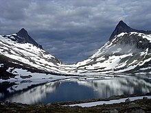
Falketind (Dovre)
| Falketind | ||
|---|---|---|
|
East side, 1985 |
||
| height | 1684 moh. | |
| location | Innlandet Province , Norway | |
| Mountains | Scandinavian mountains | |
| Dominance | 2.9 km → Halvfarhø | |
| Notch height | 225 m | |
| Coordinates | 62 ° 7 '49 " N , 9 ° 26' 54" E | |
| Topo map | 1519 III | |
|
|
||
The Falketind is a 1684 moh. high mountain in Norway . It is the third highest mountain in the Dovre National Park . It is located in the province of Innlandet and belongs to the municipality of Dovre . The notch height of the mountain is 225 m. The dominance to the next higher mountain, Halvfarhø , is 2.9 km.
Individual evidence
- ↑ a b Toppomania - Falketind 1684 moh - fakta ( Memento of the original from January 30, 2012 in the Internet Archive ) Info: The archive link was inserted automatically and has not yet been checked. Please check the original and archive link according to the instructions and then remove this notice. , toppomania.info, accessed December 28, 2011 (Norwegian)
- ↑ Map of the Dovre National Park ( page no longer available , search in web archives ) Info: The link was automatically marked as defective. Please check the link according to the instructions and then remove this notice. , dirnat.no, accessed on December 21, 2011 (Norwegian, PDF 858.42 kB)
- ↑ Map of the Dovre National Park ( page no longer available , search in web archives ) Info: The link was automatically marked as defective. Please check the link according to the instructions and then remove this notice. , dirnat.no, accessed on December 28, 2011 (Norwegian, PDF 858.42 kB) in connection with Maps Rangefinder Falketind-Halvfarhø , maps.google.de, accessed on December 28, 2011

Morka-Koldedalen, Hjelledalstind (left) and Falketind (right), 2005

