
Falsterbo Canal
| Falsterbo channel | |
|---|---|
| location | Sweden , Skåne |
| length | 1.6 km |
| Built | 1940 to 1941 |
| Beginning | Öresund , north of Höllviken |
| The End | Baltic Sea , Kämping Bay |
| Descent structures | Lock at the northern end of the canal on Falsterbovägen |
| Ports | Falsterbo north coast |
| Historical precursors | Ammerännan |
| Outstanding structures | Lock, bascule bridge Höllviksbron from 1992 and control tower from 1955 |
| Top speed. | 5 knots |
 |
|

|
The Falsterbo Canal ( Swedish Falsterbokanalen ) is an artificial waterway in the southern Swedish province of Skåne län , which shortens the distance between the Baltic Sea and the Öresund and separates the Falsterbonäs peninsula from Skåne .
description
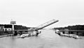
The total length of the fairway is 27 km; Of this, only 1600 m lead through the Falsterbonäs peninsula as a canal, while the rest forms a shipping channel in the sea. At the northern end there is a bascule bridge . When the bridge is closed, the maximum headroom is 3.90 m. A lock prevents an excessive current through the canal if the difference in water levels between the Baltic Sea and Öresund is too great.
The Falsterbo Canal is now crossed by 15,000 ships annually and also offers berths for small ships. The ferry to Bornholm used to pass the canal on the way between Copenhagen and Rønne . After the water depth of the canal has decreased from 6.70 m to 5 m, ships over 5000 tons can no longer pass through the canal.
When entering the canal from Höllviken , on the far left is Per Albin Linjen , a defense line named after the Swedish Prime Minister Per Albin Hansson , which was built during the Second World War . It consists of obstacles, bunkers and forts and was intended to prevent hostile landings from the sea.
history
precursor
Remnants of an original fairway, the Ammerännan , now run as a small ditch through the Skanör heath . It is assumed that the medieval canal was passable for prahm boats, a type of ship without its own propulsion, and that at least one bridge connected the southern part of the Falsterbonäs with the mainland. It is not known whether the ammerran was a natural or a dug canal.
In 1884 the politician Mårten Dahn applied in vain to the Swedish Diet (Riksdag) to build a canal through the Falsterbonäs peninsula so that shipping could bypass the dangerous Falsterboriff . Twelve years later, in 1896, fishermen from Skanör started digging a canal; But they quickly realized that the project would fail because of the effort.
Falsterbo Canal
The debate came up again during the First World War , but it was not until the Germans laid extensive mines around Falsterbonäs during the Second World War and thereby paralyzed shipping around the peninsula that the Swedish Reichstag decided on December 22, 1939, to build a canal to secure coastal shipping to put on. The Germans took no account of the three-mile zone when mining , which meant that none of the large Swedish merchant ships could safely enter or leave the Baltic Sea and they had to reload in Malmö , Trelleborg or Ystad . The Swedish state was forced to act quickly, which is why work began immediately in January 1940. The workers, mostly conscripts, first cut a swath in the heather forest and began the actual excavations in May. The breakthrough was finally achieved on July 21, 1941 and a short time later, on August 1, 1941, the first ship, the Malmö, passed the canal. There were six ministers on board the ship. The new canal, which cost 21 million Swedish kronor to build , was opened three months later on November 1, 1941. Before that, the first bridge called Knippelsbron was opened on October 4, 1940 . She was from Copenhagen and had been in the service for 50 years. In 1955 a control tower was built near the bridge. In 1992 the old bridge was replaced by a new two-lane bridge. At that time, the bridge was initially opened as required and at the discretion of the canal master, later the opening times were regulated.
gallery

View from the bascule bridge over the Falsterbo Canal - in direction south
The old Knippelsbron bridge in 1963
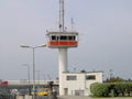
Control tower from 1955

The canal on the Kämpingebukt


Web links
- Falsterbokanalen information from the municipality of Vellinge (Swedish)
- Fördjupat program for området kring Falsterbo channels. (PDF) Miljö- och Stadsbyggnads-förvaltningen, May 19, 2005, accessed on June 27, 2017 (Swedish).
- Falsterbokanalen dates, pictures and history of the channel (Swedish)
Individual evidence
- ↑ a b c d Vellinge Kommun : Falsterbokanalen , accessed on August 30, 2010 (Swedish).
- ↑ a b c Bosse Arnholm: Falsterbokanalen in Nordens alla kanaler , accessed on August 30, 2010 (Swedish).
- ↑ Vellinge Kommun : Ammerännan , accessed on 30 August 2010 (Swedish).
- ↑ Fördjupat program for området kring Falsterbokanalen. (PDF) Miljö- och Stadsbyggnads-förvaltningen, May 19, 2005, accessed on June 27, 2017 (Swedish).
Coordinates: 55 ° 24 ′ 34 ″ N , 12 ° 56 ′ 7 ″ E