
Fangenturm (Münden)

The Fangenturm (also Kronenturm ) is a former defense tower in Hann. Münden in southern Lower Saxony . The 27.7 meter high tower was part of the medieval city fortifications of Münden and was built as a wall tower in the city wall . As with other towers , the name is based on his dungeon used as a prison .
location
The Fangenturm is located on the east side of the medieval town center. In this area the city wall ran roughly in a north-south direction. From the Fangenturm the nearest fortifications were on the city wall 130 meters away in the north with the Hampesche Turm and 75 meters in the south with a bulwark .
On the west side, the area facing the city, the catch tower is embedded in an existing building. This includes the former hotel "Zur Krone", after which the tower was named as the Kronenturm. To the east of the tower on the former side of the city lies an extensive, tree-lined park, in which ramparts of the city fortifications were found until the 19th century.
Building description
In the lower area the tower has a wall diameter of about three meters. The tower floor plan is circular, while most of the other defensive towers in the area are semicircular in shape with elongated side walls. In the upper area of the tower there is a machicolation on the south side . Liquid pitch or hot water could be poured through this to ward off attackers .
On the north side of the catch tower is a short piece of the city wall, which was about five meters high in this area. On the west side of the tower in the direction of the city, stones protrude from the tower at a height of four meters. These are earlier consoles that supported the battlements that ran along the city wall . The original access to the tower consisted of a door on the inside of the city, which could only be reached from the battlement. Today's tower entrance on the outside of the city was built in 1904 when a passage to the winter garden of the hotel "Zur Krone" was created.
The lowest interior of the tower was a dungeon with a funnel-shaped vault that was only accessible through a round opening in the ceiling. The next higher tower floor also consisted of a vault with a square ceiling opening.
The Fangenturm is one of the defensive towers of the city wall, which have largely been preserved in their original state. After the city fortifications were abandoned in the 19th century, it was not subject to any further use, such as the ferry gate tower and the Hampesche tower as scrap towers .
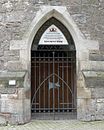
1904 created door on the city outside of the Fangenturm towards the park

Bottom view

Pechnase on the tower


history
The Fangenturm is one of the oldest towers in the city fortifications. It is mentioned for the first time in 1515 in a combing invoice from the city of Münden, while the city wall was built as early as 1200. From 1615 there is a mention of the tower as Grauer Rock . The Grimm dictionary explains the expression as "the dress of a poor sinner". The name is likely to be related to the use of the tower dungeon as a prison. In 1849 the skeleton of an adolescent was found in the dungeon . The discovery came when the tower was broken open in order to set up an equipment chamber for the cemetery in the neighboring ramparts.
In 1997 the course of the city wall between the Fangenturm and the Hampeschen Turm was archaeologically examined. The measure took place before the new construction of the Duchess-Elisabeth-Stiftes , the building facade of which approximates the course of the city wall.
See also
literature
- Johann Dietrich von Pezold: The tower of fans . In: History on the Three Rivers. A glimpse into the past of the city of Hann. Münden on the Werra, Fulda and Weser. Hann. Münden 2008, pp. 14–15.
Web links
Individual evidence
- ↑ Monument topography of the Federal Republic of Germany, architectural monuments in Lower Saxony, Göttingen district, part 1, volume 5.2, 1993, editors Urs Boeck, Peter F. Lufen and Walter Wulf, Verlag CW Niemeyer Buchverlage, Hameln, ISBN 3-87585-251-6 , p. 130.
Coordinates: 51 ° 24 ′ 57 " N , 9 ° 39 ′ 13.3" E