
Münden city fortifications

The fortification Munden consisted of the Middle Ages incurred city wall with towers and gates , the city Munden (now Hann. Münden) included. The wall, which was probably built from 1200 onwards, protected the city and the later Welfenschloss Münden from attacks. Of the former 26 towers, bulwarks and gates , 12 structures and individual parts of the city wall, some of them only rudimentary, have survived to this day.
construction

In the early days of the city, due to its location on the Werra and Fulda in the north and west, there was a natural protection. Additional protection by ramparts and moats was necessary on the south and east sides. Around 1460 the moat was built on the land side. According to a tradition from 1460, the armament consisted of 46 cannons and 79 hook rifles .
city wall
The city wall, around 1.7 km long and an average of 4.2 meters high, surrounded the entire city of Münden. It was created in the river triangle between the Werra and the Fulda and was first mentioned as a town in 1183. The city wall is believed to have been built around the year 1200. The wall is first mentioned in writing in the city register of 1387. The Welfenschloss Münden , located in the northeast corner, was included in the city fortifications, but formed a separate district within the city with the Schloss Freiheit .

A three-month rescue excavation in 1997, which was carried out in front of a new senior citizens' home for the Duchess-Elisabeth-Stift on the eastern edge of the city center, yielded essential findings about the structure of the city wall . A 90 meter long section between the Hampesche Turm and the Fangenturm was archaeologically examined. The double-shell city wall was 1.8 meters thick in the examined area and consisted of sandstone blocks that were connected by mortar . The space between the inner and outer wall shell was filled with stone waste, sand and mortar. The two meter wide and 60 centimeter high wall foundation consisted of various layers of gravel, rubble and mortar. Based on the technology and structure, the construction of this section of the city wall was dated to around the year 1200.

During the excavations it was found that the city wall did not connect the Hampesche Turm and the Kronenturm in a straight line, but in a slightly curved manner. This was due to the inclusion of an older building in the interior of the city. It was a half-timbered house 17 meters long and 10 meters wide. The five-room building could be dated to the 12th century and existed before the city wall was built. In addition, the excavations led to the discovery of an earlier bulwark , which was first mentioned in city files in 1434 as a bulwark on the Plahne and which shows a map of 1637 as a rotunda. The horseshoe-shaped structure protruding from the city wall had a diameter of about 10 meters and could have served as a ramp for guns.
Towers

The city fortifications included 26 towers, including round towers and shell towers or tower-like structures such as gates, bulwarks embedded in the city wall and the rotunda in front. Of these, 12 structures have been preserved, some only in a rudimentary way. Well-preserved towers of considerable height are the ferry gate tower, the Hampesche tower, the brick gate tower and the crown tower. The 1515 first mentioned catching tower , where a is the dungeon was, was in the vernacular as Crown Tower after the nearby Hotel Zur Krone named. The ferry gate tower, first mentioned in 1401, is named after the ferry gate as a gate in the city wall. Like the other towers of the city fortifications, it was around 26 meters high. After the decline of the city fortifications, the entrepreneur Carl Georg August Natermann ( Haendler & Natermann ) acquired the ferry gate tower in 1848 and had it raised by a third to a height of 40 meters for shotgun production. The Hampesche Turm experienced this subsequent use and a similarly high increase to 42 meters from 1848. In the 15th and 16th centuries it was referred to as the "New" or "Hollow Tower". The brick gate tower received a breakthrough for pedestrians in the 1930s, as the road was widened for traffic reasons. In the south-eastern part of the city wall there was a powder tower near the Aegidienkirche , which was destroyed by an explosion shortly after the conquest of Münden by the troops led by Johann T'Serclaes von Tilly in 1626. The tower stump has been preserved to this day.
Another tower was discovered when the old Packhof was converted into a hotel in 1999. In the ground under the building there were stone remains of the city wall and foundation stones of a previously unknown tower of the city wall. The foundations of the horseshoe-shaped tower were 1.6 meters wide. When the Old Packhof was built at the beginning of the 19th century, the remains of the medieval building were built over.
The only square tower is located on the Dielengraben near the Welfenschloss. It has a height of 10 meters and a size of about 4 × 3 meters. Its outer wall corresponds to the strength of the city wall in this area with almost 1.3 meters, which is 6.5 meters high here. Under the tower the Beke flowed with sewage from the city.

Ferry gates tower (also hail tower Natermann tower), for Schrotturm increased

Hampescher Turm , raised to a scrap tower

Fang tower , also known as the crown tower

Blunt tower on the Kasseler Schlagd
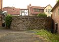
Old Sydekum bulwark at the Schlagd -pitze, built over with a residential house in 1729
The stump of the powder tower on the street Am Wall, which exploded in 1626

Bulwark at the Welfenschloss Münden

Powder tower of the Welfenschloss Münden

The nearly 9 meter high thin tower


rotunda

The Mündener rotunda was established on 1318 first mentioned gate Upper Gate . Initially, the Upper Gate had a gate tower and a drawbridge . In 1500 Duke Erich I had the rotunda with a diameter of 17 meters and a defensive tower built as an outside bastion with a city gate. In 1776 the city gate at the rotunda was demolished due to the construction of a road . The defense tower on the rotunda was demolished in 1847. The rotunda was preserved and continued to be used for various purposes. In 1985 and 1986, due to the increasing destruction of the building by vegetation and roots, a renovation was carried out for 880,000 DM . In 2016, plans were announced to use the rotunda for cultural events.
Sieges

After the Battle of Sievershausen in 1553, Duke Heinrich II's troops besieged the city of Münden and took it after it was starved. Duchess Elisabeth , who had Münden for body breeding , was expelled. During the Thirty Years' War, Tilly's troops besieged the town in 1626, which was garrisoned by 800 Danish soldiers. Tilly's mercenaries with a strength of 10,000 men took Münden after a five-day siege with fire. They wreaked havoc among the population, killing the occupation and about 2,000 residents. Thus, in two cases in the 16th and 17th centuries, Münden was not defensible despite its city fortifications, and in 1626 because of unsuccessful buildings. After the advent of firearms in the 14th century, the city wall was not reinforced and could easily be destroyed by cannon fire.
Laying down
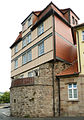
In 1836, the city council of Münden decided to demolish the stone fortifications in order to expand the city. The city acquired the fortification site for 1000 thalers from the Royal Ministry of War. To a large extent this led to the removal of the fortifications by removing walls and ramparts and filling in trenches. About three longer sections and about six shorter sections have survived to this day. Some areas of the city wall have been preserved because residential houses sitting on them were built as so-called wall houses. City wall towers , such as the ferry gate tower and the Hampescher tower, remained because they were used commercially.
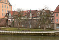
City wall area built over with wall houses at the Dielengraben next to the Welfenschloss (left)

Residential houses on the Wanfrieder Schlagd built on the city wall

City wall as a building wall


literature
- The rotunda at the Upper Gate in Münden. History and restoration 1985-1986 , published by the city of Münden, Hann. Münden, 1990
- Monument topography Federal Republic of Germany , architectural monuments in Lower Saxony, district of Göttingen, part 1, volume 5.2, 1993, editors Urs Boeck , Peter F. Lufen and Walter Wulf, Verlag CW Niemeyer Buchverlage , Hameln, ISBN 3-87585-251-6
- Andrea Bulla: City wall and traces of settlement from the founding time of the city of Hann. Münden, preliminary report on the 1997 excavation in: Dug - Found - Secure. Archaeological search for traces on the Werra, Fulda and Weser. , Ed. On behalf of the city of Hann. Münden by Johann Dietrich von Pezold, Hann. Münden, 1998
- Andrea Bulla: City wall and traces of settlement from the founding time of the city of Hann. Münden, district of Göttingen in: Reports on the preservation of monuments in Lower Saxony , 1/1999, pp. 45–47.
- Johann Dietrich Pezold: The old fortifications of the city in: History on the three rivers. A glimpse into the past of the city of Hann. Münden on Werra, Fulda and Weser , Hann. Münden, 2001, pp. 16-20.
Web links
Individual evidence
- ↑ Sunday, September 11, 2005 (Open Monument Day) (pdf)
- ↑ City fortifications and development
- ↑ a b Hampe tower "Hagelturm"
- ↑ Fang Tower (Crown Tower)
- ↑ Brick Gate Tower
- ↑ Johann Heinrich Zacharias Willigerod: History of Münden, in an excellent way on action and shipping , Göttingen, 1808
- ↑ Pierre Hattenbach: Fortifications in sight at HNA Regiowiki