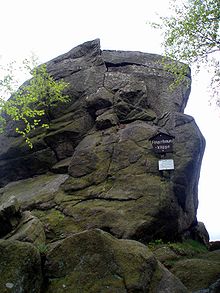
Fig tree cliff
The fig tree cliff , also known as the fig tree pulpit , is a granite rock formation east of the Oker valley in the Harz Mountains . It is located near Romkerhalle in the non-parish Harz region of the Lower Saxony district of Goslar . Your rocks show clear signs of wool sack weathering .
Geographical location
The fig tree cliff is located in the Upper Harz in the Harz Nature Park around 800 m northeast of the Romkerhalle settlement (approx. 335 m above sea level ) on the southwest flank of the Huthberg ( 604.8 m ) at around 540 m altitude; its highest point ( ⊙ ) is in the southeast of the rock formation. To the west the landscape falls to the Oker with federal road 498 ( Oker –Romkerhalle– Okerstausee - Altenau ).
Hiking and viewing opportunities
The hiking trail leads past the fig tree cliff from the Käste cliffs to the Romkerhall waterfall . The rock formation is a popular hiking destination, and its viewing platform ( ⊙ ) offers views to the west of the Okertal. The platform is secured by a railing.
See also
Individual evidence
- ↑ Map services of the Federal Agency for Nature Conservation ( information )
- ↑ Die Feigenbaumklippe , accessed on May 21, 2010
Coordinates: 51 ° 51 ′ 49.5 " N , 10 ° 28 ′ 50.8" E
