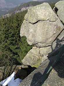
Box cliffs

The Kästeklippen , also called Käste , near Romkerhalle in the community-free area of Harz in the Lower Saxon district of Goslar are a rock group of the Huthberg ( 604.8 m above sea level ) in the Harz , the highest point of which is the mountain summit. The granite rocks show the typical weathering of wool sacks in the Harz . The cliff area may have been the scene of ritual acts earlier. On the summit region of the Huthberg, the Kästehaus mountain restaurant stood near the cliffs .
Geographical location
The Kästeklippen lie in the Harz Nature Park downwards along the Oker , between the villages of Schulenberg in the southwest and Oker in the north, about 1.3 km (as the crow flies ) northeast of the Romkerhalle hotel and restaurant, which is about 355 m above sea level on the river . You are in the Upper Harz on the northwest part of the summit region of the wooded Huthberg , while the highest point is its summit ( 604.8 m ). The landscape of the mountain slopes down along the cliffs to the west to the deeply cut valley of the Oker. A protruding rock directly on the viewing platform resembles the face of an old man and is therefore called the old man from the mountains . In the vicinity of the rock group are among other things the witch's kitchen , the fig tree cliff / pulpit, the mousetrap and the stone staircase .
Opportunities for viewing
From the summit of the Kästeklippen there is a view of the Oker valley, down to the Oker district of Goslar and the Sudmerberg east of the Sudmerberg district , but also up to the Brocken . When the visibility is good, it extends far into the northern Harz foreland , including Braunschweig and the Buschhaus power station near Helmstedt .
Traffic and walking
The most important access route to the Kästeklippen is Kästestrasse , which is closed to public motor vehicle traffic. It leads from Bad Harzburg up to Schlackenplatz on the Morlberg and then runs at a height of almost 600 m over the Alte Schlewecke and past the Stiefmother cliffs to the Käste cliffs. From there it runs downhill, past the Hinteren and Vorderen Ziegenücken to the Goslar district of Oker. The road was once completely paved from Bad Harzburg to Käste. Remains of the asphalt surface can still be seen today.
Numerous forest paths and paths lead up to the Käste cliffs, which are popular as a hiking destination, for example starting at the Okertalsperre , at Romkerhalle as well as in Oker , Göttingerode and Bad Harzburg .
The Kästehaus mountain restaurant , which was located on the summit region of the Huthberg near the cliffs in 1928, was in operation until the beginning of 2018 . In the autumn of the same year, the building was torn down and a new building was subsequently built, which should again accommodate a refreshment stop. After the Second World War there were plans to build a chairlift to the Kästeklippe, but they were never realized.
gallery
Kästehaus near the summit of the Huthberg
See also
Web links
Individual evidence
- ↑ Map services of the Federal Agency for Nature Conservation ( information )
- ↑ a b The Staircase Stone, on harzlife.de, accessed on May 21, 2010
Coordinates: 51 ° 52 ′ 6 ″ N , 10 ° 29 ′ 0 ″ E


