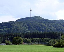
Telecommunication tower Plettenberg
|
Telecommunication tower Plettenberg
Radio transmission point Schömberg Balingen 2
|
||
|---|---|---|
| Basic data | ||
| Place: | Plettenberg , Dotternhausen | |
| Country: | Baden-Württemberg | |
| Country: | Germany | |
| Altitude : | 1000 m above sea level NN | |
| Coordinates: 48 ° 13 ′ 4.1 ″ N , 8 ° 48 ′ 55 ″ E | ||
| Use: | Telecommunications tower , broadcasting station | |
| Accessibility: | Transmission tower not open to the public | |
| Owner : | German radio tower | |
| Tower data | ||
| Construction time : | 1979-1980 | |
| Operating time: | since 1980 | |
| Total height : | 158 m | |
| Operation room: | 99-108 m | |
| Data on the transmission system | ||
| Send types: | Cellular radio , directional radio | |
| Position map | ||
|
|
||
The telecommunications tower Plettenberg (also known as the radio transmission point Schömberg Balingen 2 ) is a 158 m high transmission tower ( type tower made of reinforced concrete, FMT 13) of Deutsche Telekom AG near Dotternhausen in Baden-Württemberg . The type tower stands on the northern tip of the Plettenberg at 1000 m above sea level.
Amateur radio

Plettenberg, North view of Erzingen from
The amateur radio relay DB0HP was located on the Plettenberg telecommunications tower for a long time. In addition to the voice relay, a packet radio digipeater was also set up. In 2007 the relay could no longer be operated and the DB0SKF voice relay near Freudenstadt now covers parts of the Black Forest .
Individual evidence
- ↑ http://www.funk-server.com/relais.htm
- ↑ DB0HP QRT - DARC local association Titisee A34. Retrieved January 2, 2018 (German).
- ↑ End of July: DB0HP makes QRT - Amateurfunk-Oberschwaben eV Accessed on January 2, 2018 (German).


