
Findigkofel
| Findigkofel | ||
|---|---|---|
 The Findeigkofel in the Carnic Alps |
||
| height | 2016 m above sea level A. | |
| location | Carinthia , Austria , and Friuli-Venezia Giulia , Italy | |
| Mountains | Carnic main ridge | |
| Dominance | 2.9 km → Hoher Trieb | |
| Notch height | 219 m ↓ Zollnertörl | |
| Coordinates | 46 ° 35 '46 " N , 13 ° 6' 3" E | |
|
||
| rock | Phyllite , slate | |

The Findeigkofel (Italian: Monte Lodin ) is a 2016 m above sea level. A. high mountain in the Carnic Alps , which lies in the border area between the Austrian state of Carinthia and the Friuli-Venezia Giulia region in Italy .
history
During the First World War , after Italy's declaration of war on May 23, 1915, the Findeigkofel was located in a fiercely contested section of the front line between the Austro-Hungarian Empire and Italy . Just two days after the Italian declaration of war, the mountain was captured by Italian troops and only after repeated unsuccessful attacks by the Austrians was their 12th mountain brigade finally able to recapture it in mid-September 1915. The mountain remained under Austrian control until the end of the war.
literature
- Erwin Steinböck: The battles for the Plöckenpass 1915/17 . Military historical series, issue 2. Österreichischer Bundesverlag Gesellschaft mb H., Vienna 1988, ISBN 3-215-01650-8 .
photos
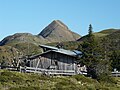
The Findeigkofel, with the Zollnerseehütte in the foreground
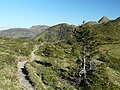
The Karnische Höhenweg with the Findeigkofel in the background

The summit cross of the Findeigkofel


Web links
- Hiking tour from the Zollnerseehütte to the Findeigkofel
- The Findigkofel on summitpost.org , accessed on December 2, 2011