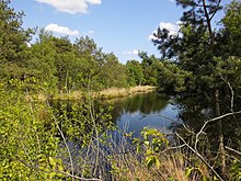
Fintlandsmoor
Coordinates: 53 ° 10 ′ 13.9 ″ N , 7 ° 53 ′ 48.9 ″ E
The Fintlandsmoor is a dehydrated and largely abgetorftes high moorland in Lower Saxony, District of Ammerland . Part of the moor was designated as a nature reserve " Fintlandsmoor " in 1987 , which was added to the nature reserve " Fintlandsmoor and Dänikhorster Moor " in 2017 .
Emergence
The Fintlandsmoor was created over thousands of years in a deep hollow in the ground made of impermeable stone , the edges of which were formed by high ridges of sand so that the water could not run off. A raised moor up to 3.5 m thick formed . The original area of the Fintlandsmoors was 2814 ha and extends south of the river Alte Ollenbäke near Ocholt-Howiek to north of the river Aue in Westerscheps / Osterscheps and Dänikhorst. The moor developed undisturbed until the middle of the 19th century.
cultivation
1877–1931: Peat and Moorgut Karlshof
Since 1877, the marsh was planned abgetorft . The "Ocholt peat plant" was founded on the northern edge of the Fintland moor for economic use . By 1880, 135 hectares of moorland had been acquired, drained by means of drainage ditches and then removed by peat excavators. The dried peat was mainly taken from the Grand Ducal Oldenburg Railway , whose locomotives were mostly peat-fired. The peat was removed by a 3 km long field railway , the carts of which were pulled by horses (“horse train”) to today's Westerstede-Ocholt station. The humid summer of 1880 and the conversion of the Oldenburg locomotives from peat to coal firing put an end to the first phase of peat mining in 1881, and large areas were returned to the Oldenburg state . The peat factory, including 35 hectares of remaining land, was sold to Carl Vellguth in 1884 . Since peat extraction became increasingly unprofitable, Vellguth founded an agricultural moorland that is still partially recognizable today and enlarged it to 57 hectares, half of which was used for pasture farming. To improve yields, he relied on moorland dam culture , which was supposed to make arable farming possible. For this purpose, around 10 hectares of peated high moor were covered with clay from the Jade Bay . The enormous costs of this procedure led the estate to bankruptcy in 1897. The following year it was sold, but grew to 418 hectares (210 hectares of pasture and arable land, 9 hectares of roads and buildings, 199 hectares of uncultivated moor) through acquisitions.
Karlshof: settlement since 1933
In 1931 the estate with 30 hectares of land was leased, in the following year 139 hectares of uncultivated raised bog, 120 hectares of grassland and 30 hectares of arable land were acquired by the state settlement office. The reasons for the state purchase of land were the economic hardship of many people (colony evictions for agricultural acquisition) and a new possibility of large-scale peat removal by the newly established Strenge peat factory from Ocholt. In the meantime, the company had leased larger areas in order to remove them with self-constructed large excavators. These industrial peat bog areas were also available for cultivation and settlement.
Through state emergency work (1932: voluntary labor service, 1933: Reich labor service ), 76 hectares of moorland with low peat levels of 1 - 1.5 m were plowed up to the Ortstein ("cooled") and kilometers of main waterways, the colonial border ditches, were dug . The new area drainage takes place in the floodplain. Three main routes were also established. Then 35 colonies were identified on the 319 hectares made agriculturally productive in this way (22 full farms with approx. 12 hectares, 13 part-time jobs with 2 to 7 hectares). The colonists received financial support through amelioration loans and cultivation grants. The settlement, which has been developing according to plan since 1933, was named "Karlshof" (after Carl Vellguth, see above). During the Second World War , today's Klinkerstrasse Karlshofer Strasse was paved with the help of French and Belgian prisoners of war who were interned in the moor. At the same time, Polish civil workers were employed by the Strenge company and on the estate. In 1942 prisoners of war and civilian workers from the Soviet Union were added. Some prisoners from the Esterwegen concentration camp were also used to cut peat in the moorland.
Wittenriede: post-war settlement in the moor
In the post-war period, the cultivation of the Fintland moor progressed, especially with the influx of many displaced persons . In 40 years the arable land area in Karlshof grew from originally 30 hectares by 1975 to 198 hectares. A further 300 hectares had meanwhile disappeared due to mechanical peeling by the Strenge company. Untouched bog areas were hardly left. At the same time, after the war, a new cultivation focus emerged in the southern area of the Fintland moor, which was now mechanically plowed deep with Ottomeyer locomobiles without peeling ( mixed sand culture ). The Wittenriede settlement was laid out in 1955 on the agricultural land that was created in this way.
1970: Protection of residual moor areas
In 1970 around 30 hectares of the remaining moor were placed under nature protection. Since then the area has been increased considerably to almost 140 hectares. The moor complex also includes 20 hectares of the adjacent Dänikhorster moor . With sand dams and barrages in the drainage ditches, renaturation through rewetting is sought in both areas .
Bees
In 1978, 77 species of bees were found in a birch stand and a moorland area of disturbed raised bog remains.
Web links
supporting documents
- ↑ Paul Westrich : Die Wildbienen Deutschlands , 2nd edition, Eugen Ulmer, Stuttgart 2019, p. 17.

