
Fishing peninsula
| Fishing peninsula | ||
 Osjorko Bay |
||
| Geographical location | ||
|
||
| Coordinates | 69 ° 42 ' N , 32 ° 36' E | |
| Waters 1 | Barents Sea | |
| surface | 1 200 km² | |
 The area of Petsamo in limits from 1920 to 1944. Green: ceded in 1940, Red: ceded 1947th In the northeast, the fishing peninsula |
||

The fishing peninsula ( Russian Полуо́стров Рыба́чий (Poluostrow Rybatschi); Finnish Kalastajasaarento ) is the northernmost part of continental European Russia . The peninsula lies on the Barents Sea . In the south it is bordered by the Motowski Bay .
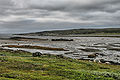
It belongs to the Murmansk Oblast and is close to the border with Norway . The area of 1200 km² is covered by tundra . There are only smaller settlements there. The highest point on the fishing peninsula is 299 m .
history
The western part of the peninsula belonged to Finland from 1920 . After the winter war of 1940, however, it was ceded to the Soviet Union along with other areas in the Peace of Moscow .
From 1942, the German Wehrmacht and the Wiesengrund company were planning a landing behind the Soviet positions on the North Sea. The plan was abandoned in 1944.
A memorial commemorates the fallen of the Red Army.
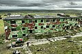
Crumbled buildings

Vaida lighthouse

The village Cypnavolok
Shipwreck


Web links
Individual evidence
- ↑ Fischer Peninsula ( Memento from April 18, 2013 in the web archive archive.today ) in the geographical name database of Yandex (Russian)
- ↑ Article Fisher Peninsula in the Great Soviet Encyclopedia (BSE) , 3rd edition 1969–1978 (Russian)
- ^ Jürgen Rohwer , Gerhard Hümmelchen : Chronicle of the naval war 1939-1945