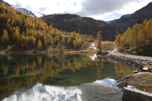
Fischersee (Ultental)
| Fishing lake | |||||
|---|---|---|---|---|---|
| Fishing lake in Ultental / South Tyrol | |||||
|
|||||
|
|
|||||
| Coordinates | 46 ° 28 '37 " N , 10 ° 49' 37" E | ||||
| Data on the structure | |||||
| Lock type: | dam | ||||
| Construction time: | Commissioning: 1963 | ||||
| Crown length: | 140 m | ||||
| Operator: | Alperia Greenpower GmbH | ||||
| Data on the reservoir | |||||
| Altitude (at congestion destination ) | 2064 m slm | ||||
| Water surface | 1.8 ha | ||||
| Storage space | 28,000 m³ | ||||
The Fischersee ( Italian: Lago dei Pescatori ) is a small reservoir in the area of the upper end of the Ulten Valley in South Tyrol . It is located about one kilometer southwest and 192 m above the Weißbrunnsee , at an altitude of 2064 m . It has a capacity of 28,000 m³ with a water surface of around 1.8 ha. The water is located in the Stelvio National Park .
The Fischersee has a dam that is slightly angled in the middle and is about 140 m long and serves as a water reservoir for the pumped storage operation of the Weissbrunn power station , which pumps 1.4 m³ of water per second from it up to the 2529 m high Grünsee from which it flows into High consumption times with a head of 641 m in the turbine of the power plant is used.
literature
- SE Hydropower GmbH: hydropower plants Ultental , folder, ( digitized )
Web links
- Fishing lake on ultental-valdultimo.com

