
Weißbrunnsee
| Weißbrunnsee | |||||||
|---|---|---|---|---|---|---|---|
 |
|||||||
|
|||||||
|
|||||||
| Coordinates | 46 ° 29 '7 " N , 10 ° 49' 58" E | ||||||
| Data on the structure | |||||||
| Lock type: | 2 earth embankments | ||||||
| Construction time: | 1957-1959 | ||||||
| Height of the structure crown: | 20.5 m (this and the following values for main embankment) | ||||||
| Building volume: | 80 000 m³ | ||||||
| Crown length: | 229 m | ||||||
| Base width: | 65 m | ||||||
| Power plant output: | 44 MW | ||||||
| Operator: | Alperia Greenpower GmbH | ||||||
| Data on the reservoir | |||||||
| Altitude (at congestion destination ) | 1872 m (max. Congestion destination 1873 m) | ||||||
| Water surface | 0.16 km² | ||||||
| Reservoir length | 420 m | ||||||
| Reservoir width | 440 m | ||||||
| Storage space | 1.67 million m³ | ||||||
| Catchment area | 21.45 km 2 | ||||||
| Particularities: |
Pressure tunnel to the St. Walburg power plant |
||||||

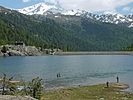
The Weißbrunnsee ( Italian Lago di Fontana Bianca ) is a reservoir in the upper Ulten Valley in South Tyrol . It belongs to the chain of reservoirs and hydropower plants in the Ulten Valley , which Alperia Greenpower GmbH operates for the electrical energy use of the valley's hydropower.
Location and tributaries
The Weißbrunnsee is about 1871 m above sea level at the end of the northern branch of the Ultental (Flatschbergtal), which branches off in St. Gertraud , the last town in the valley. After about six kilometers from St. Gertraud, the road ends at the lake. This is the ideal starting point for hikes in the eastern part of the Stilfserjoch National Park , which also includes the lake.
The wrong ones

The discharge inlet


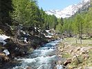
The natural tributary to the Weißbrunnsee is the Falschauer . But there are more through artificial water structures. The main part is the runoff water from the Weissbrunn power plant , which is opposite the dam on the west bank of the lake. It draws its usable water from pressure tunnels and pipes from the Grünsee and the Fischersee . In addition, water is collected by means of water catchments in the valleys of the Kirchbergbach and Klapfbach (right tributaries of the Falschauer) and fed via pressure pipes to the east side of the Weißbrunnsee and discharged there.
The dams
An approximately 150-meter-wide elevation in the middle of the valley meant that the dam could be constructed in two parts, which are at an angle of approximately 120 degrees to each other. They are embankments .
View of the main dam

The secondary dam


The northern main dam has a crown length of 229 m and a height of 20.5 m. At the foot it is 65 m wide and its total volume is 80,000 m³. The southern dam is a little shorter and also has a lower height.
The storage target of the facility is 1872 m, the maximum storage target one meter above. The storage space of the lake is 1.67 million m³.
A circular path of a good two kilometers in length leads around the lake, which runs over the top of the main dam and bypasses the secondary dam.
Power plant integration
The power plant belonging to the reservoir is not located on the dam, but at a distance of 11 km as the crow flies and 730 m lower on the west bank of the Zoggler reservoir and is called the St. Walburg power plant . The water is directed to the St. Walburg power plant via a pressure tunnel and finally a pressure line after it has previously combined with the runoff water from the Kuppelwieser Alm power plant .

In the power plant, the water meets two Pelton turbines with a horizontal axis and generates a maximum output of 44 MW.
Normally, the Weißbrunnsee does not have an open drain. The main dam only has an overflow device for an excess of water, through which the water is led steeply to the dam bottom and from there follows the natural course of the Falschauer, which is then fed by tributaries.
history
In 1957, work on the construction of the lake, combined with the construction of the St. Walburg power station, began and was completed in 1959. Most of the Untere Weißbrunn-Alm sank into the floods.

During the construction of the dams, a settlement of barracks was created for the construction workers. There was a company canteen to supply them, which was established as the “Enzian” (La Genziana) excursion restaurant after the construction work was completed.
The Piedmontese chef Giancarlo Godio was already employed here when the dam was being built . Later he took over the restaurant as a son-in-law and made it famous with his culinary art by combining the cuisine of Ulten with the Italian. In 1978 he was the first chef in South Tyrol to receive a Michelin star . High-ranking guests landed on a helipad on the lake to visit the restaurant. In 1994 Giancarlo Godio was killed in a plane crash. The former inn is closed.
The “Zur Knödlmoidl” mountain inn is now taking over the catering at Weißbrunnsee.
literature
- Christoph Gufler: The lost legacy: the power plant and reservoir construction in Ulten and Lana , Verlag-Anst. Athesia Bozen, 2007, ISBN 978-88-8266-096-3
- SE Hydropower GmbH: hydropower plants Ultental , folder, ( digitized )
- Blue group: Giancarlo Godio. a star for bonne cuisine , Verlag Gamsblut Bozen 2009
Web links
- Weißbrunnsee on ultental-valdultimo.com
- Under power - reservoirs and power plants in Ultental (video)