
St. Gertraud (Ulten)

St. Gertraud ( Italian Santa Gertrude ) is about 200 inhabitants extensive fraction of the municipality of Ultimo in South Tyrol .
location
St. Gertraud is the last village in the rear Ultental . It is about 1500 m above sea level. The Stilfserjoch National Park begins behind the village . It is directly overlooked by the 2,469 m high nail stone , a little further into the valley above the valley head is the highest mountain in the Ulten Valley, the 3443 m high Hintere Eggenspitze . The Falschauer rises nearby and drains the entire Ulten Valley and flows into the Etsch at Lana . At St. Gertraud, two high valleys branch off from the Falschauer valley, the Kirchberg valley to the south and the Flatschberg valley to the north. They are accessed via alpine pastures or hiking trails. A narrow road leads from St. Gertraud to Weißbrunnsee , where it ends after about six kilometers at an altitude of 1,885 m at the Untere Weißbrunneralm.
Attractions
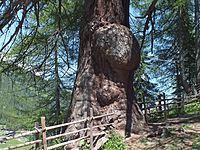
Trunk of one of the ancient larches

The Lahnersäge


- The three Url larches are located near St. Gertraud . The age of the registered natural monuments is estimated at 850 years.
- The Lahnersäge is a national park center of the Stilfserjoch National Park . It operated as a sawmill until the 1980s. Today the completely restored saw, powered by the Falschauer, is only used for demonstration purposes.
Web links
Coordinates: 46 ° 29 ' N , 10 ° 52' E