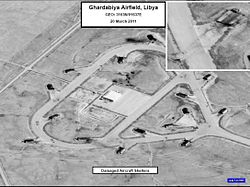
Gardabya airport
| Gardabya airport | |
|---|---|

|
|
| Characteristics | |
| ICAO code | HLGD |
| IATA code | SRX |
| Coordinates | |
| Height above MSL | 81 m (266 ft ) |
| Transport links | |
| Distance from the city center | 16 km south of Sirte , Libya |
| Runways | |
| 13/31 | 3600 m × 45 m asphalt |
| 18/36 | 3600 m × 45 m asphalt |
The Ghardabiya Air Base ( English : Gardabya Airport ) is the military and civilian use airport of Sirte in Libya .
location
The airport is 16 km south of the city of Sirte and two kilometers west of Qasr Abu Hadi . The airport area is on the road to Waddan .
Airfield features
The tower (TWR) sends and receives on the frequency 118.6 MHz . The airport has various navigation aids. The non-directional radio beacon (NDB) transmits on the frequency: 407 kHz with the identifier SRT . The location denial is 2 ° East. (Status: 2006)
services
For civil air traffic, Libyan Airlines offers national flights e.g. B. to Tripoli International .
The airport was home to the 1124th Squadron of the Libyan Air Force and has been controlled by the Islamic State since June 2015 . According to ASN , there are no known accidents near the airport.
Web links
- Airport data in the Aviation Safety Network (English)
- Airport data on World Aero Data ( 2006 )
Individual evidence
- ↑ Airport data on World Aero Data ( English, as of 2006 )
- ↑ A Case of Who You Want to Believe. (No longer available online.) In: The Tripoli Post. Archived from the original on April 17, 2015 ; Retrieved March 7, 2011 . Info: The archive link was inserted automatically and has not yet been checked. Please check the original and archive link according to the instructions and then remove this notice.
- ^ Civil war in Libya: IS suppresses uprising in Sirte. In: spiegel.de. August 17, 2015, accessed March 19, 2016 .
- ↑ Airport data in the Aviation Safety Network (English)