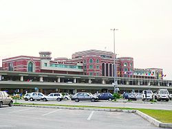
Allama Iqbal International Airport
| Allama Iqbal International Airport | |
|---|---|

|
|
| Characteristics | |
| ICAO code | OPLA |
| IATA code | LHE |
| Coordinates | |
| Height above MSL | 213 m (699 ft ) |
| Basic data | |
| Passengers | 4,724,694 (2015/16) |
| Air freight | 81,148 t (2015/16) |
| Flight movements |
34,934 (2015/16) |
| Runways | |
| 18L / 36R | 3310 m × 46 m concrete |
| 18R / 36L | 2900 m × 46 m asphalt |
The Lahore Airport ( english Allama Iqbal International Airport , Urdu علامہ اقبال بین الاقوامی ہوائی اڈا) is the third largest airport in Pakistan .
Location and directions
The airport is located near the city of Lahore . One of the ways to get to the airport by car is via Barki-Road.
The tower (TWR) sends and receives on the frequency : 118.1 MHz . The airport has various navigation aids. The non-directional radio beacon (NDB) transmits on the frequency: 268 kHz with the identifier: LA. The rotating radio beacon (VOR) transmits on frequency: 112.7 MHz with the identifier: LA. A distance measuring equipment (DME) is present.
Incidents
None of the ten accidents in the vicinity of the airport recorded in the ASN database were killed. The last incident occurred in May 2009 when an ATR-42 aircraft was badly damaged on landing and the nose landing gear was destroyed.
See also
Web links
- Airport website. Retrieved August 20, 2010 .
- Airport data in the Aviation Safety Network (English)
- Airport data. In: flightstats.com. Retrieved August 20, 2010 .
- Airport data on World Aero Data ( 2006 )
- Airport. In: AirNav. Retrieved August 20, 2010 .
- Airport data. In: The Airport Guide. Retrieved August 20, 2010 .
Individual evidence
- ↑ a b c Major Traffic Flows By Airports During The Year July 2015 / June 2016. (PDF) In: caapakistan.com.pk. Pakistan Civil Aviation Authority, accessed March 15, 2018 .
- ↑ Airport data on World Aero Data ( English, as of 2006 )
- ↑ Airport data in the Aviation Safety Network (English)
- ↑ Aircraft accident data and report in the Aviation Safety Network (English)