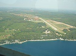
Vrsar airfield
| Vrsar | |
|---|---|

|
|
| Characteristics | |
| ICAO code | LDPV |
| Coordinates | |
| Height above MSL | 37 m (121 ft ) |
| Transport links | |
| Distance from the city center | 3.5 km southeast of Vrsar |
| Local transport | taxi |
| Basic data | |
| operator | North Adria Aviation |
| Start-and runway | |
| 18/36 (previously 01/19) | 700 m × 18 m asphalt |
The airfield Vrsar is located about 3.5 kilometers southeast of Vrsar , on the peninsula of Istria in Croatia. It is served by general aviation . It has been open to international air traffic all year round since 2018. In addition, the airfield is used, among other things, by sport planes, which carry out panoramic and parachute flights all year round. The operator is North Adria Aviation . The ICAO code is LDPV. Vrsar Radio has a frequency of 126.650 MHz.
The airfield has an asphalt runway with an extension of 700 × 18 m in the direction north / south (18/36) with a very nice approach and departure over the Limski Canal . Further facilities include an aircraft hangar and a restaurant , which is open in the summer months, in the immediate vicinity. A taxi is available on site.
Web links
Individual evidence
- ↑ Travel information Vrsar. P. 30 , accessed December 19, 2009 .
- ↑ Airports in Croatia. Air Broker Center International AB, accessed December 19, 2009 .