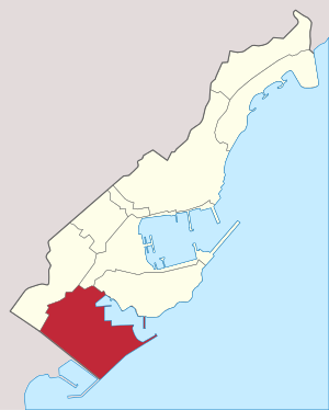
Fontvieille (Monaco)
|
Fontvieille municipality of Monaco |
|
|---|---|
| Coordinates | 43 ° 43 '46 " N , 7 ° 24' 54" E |
| surface | 0.329,516 km² |
| Post Code | 98000 |
| prefix | +377 |
Fontvieille ( Monegasque Funtanaveya ) is a district ( French quartier ) in the Principality of Monaco on the Côte d'Azur . It represents the southernmost part of the city-state . Fontvieille has an area of 0.33 square kilometers (32.95 hectares) and borders the Monegasque districts Jardin Exotique , La Condamine and Monaco-Ville as well as the French municipality Cap-d'Ail .
In contrast to the other urban districts of Monaco-Ville, Monte-Carlo and La Condamine, Fontvieille is practically completely built on artificially heaped terrain and thus represents the youngest part of the small state. In order to counter the chronic lack of building land in the very densely populated Monaco, 1966 under the rule of Rainier III. started to break new ground in the sea southwest of the Rocher , the old town of Monaco, directly on the border with France. In 1981 the then Hereditary Prince Albert (since April 6, 2005 Prince Albert II) laid the foundation stone for the new district.
Web links
- gouv.mc - website of the Government of the Principality of Monaco
- palais.mc - Website of the Palace of the Principality of Monaco
- mairie.mc - Website of the Mayor of the Principality of Monaco
Individual evidence
- ^ Ordonnance Souveraine n ° 4.481 on September 13, 2013 ( Memento of December 14, 2014 in the Internet Archive ). Journal de Monaco (Bulletin Officiel de la Principauté). Retrieved December 23, 2014.
- ↑ monaco statistics pocket, edition 2014 ( PDF ; 4.5 MB ). Principality of Monaco. Retrieved December 23, 2014.


