
Fonuafoʻou
 | |
Location of Fonuafoʻou |
Coordinates: 20 ° 19 ′ S , 175 ° 25 ′ W

Fonuafoʻou or Fonuafoou , other name Falcon Island , also known as "The Lost Island", is a short-lived, volcanic island in the Haʻapai group of islands in the South Pacific , which belongs to the Kingdom of Tonga . It is located 63 km west of Nomuka Island and 24 km north of Hunga Tonga , the closest island. The name "Falcon Island", which is common in Europe, goes back to the British warship HMS Falcon at Australia Station , whose crew measured a shoal at this point in 1865 .
geology
Fonuafoou is the summit of a submarine volcano , which temporarily grows above the surface of the sea and then completely erodes its tip again, so that no land is visible above sea level. The chemist and geologist Edward Hoffmeister (1899–1991) from Johns Hopkins University in Baltimore , who visited Falcon Island in May 1928, found that the island consists mainly of basaltic rocks, which are usually very finely grained and colored by iron oxides are. The Fonuafoou volcano does not emit any lava flows when it erupts, it only erupts loose material. Therefore, the land area accumulated from it can be removed by wind and waves after a short time, so that the island disappears again below sea level within a few years.
outbreaks
We owe the first report about Fonuafoou to the Spanish captain Francisco Antonio Mourelle de la Rúa (born July 17, 1750 in Corme , † May 24, 1820 in Cádiz ). In 1781 he sailed the Pacific Ocean with the frigate La Princesa . When he called Tonga in February 1781, he sighted an elevation in the Haapai group that he called "Las Culebras". It was probably the island of Fonuafoou. In 1877, the sloop HMS Sappho stationed in Australia registered a large cloud of smoke rising from the ocean. In an eruption in 1885, a volcanic cone rose to 88 m above sea level and formed an island about 3 km in diameter. It disappeared again under the sea in 1898, but rose again in 1927 to a height of 30 m. After that it grew steadily and in 1933 was already 127 m high. The last visible eruptions so far occurred in 1936. Now erosion started again and the island disappeared below sea level again in 1949. Today there is a shoal of 17 m at this point. However, the 1984 Admiralty Sailing Directions of the Royal Navy's Hydrographic Institute reported volcanic activity at 20 ° 85 'S, 175 ° 55' W in 1970. The report could not be verified during a 1974 review. The entry suggests that the Navy received the reference to volcanic activity from a passing ship.
Research expeditions
1889
In 1889 there was a British research expedition with HMS Egeria to the island that had been newly created four years earlier. As the expedition report describes, the island consisted of a loose, fine-grained, dark gray volcanic ash that was piled up in layers, interspersed with volcanic bombs . At this point two craters had formed. There were no recent eruptions, but sulfur fumes were in the air and the island's surface had not yet cooled completely. A soil temperature of 40 ° C was measured at a depth of 1.8 m. In some places, individual seed plants had already established themselves. Two young coconut palms even grew on a shallow section of the coastline . The members of the expedition could not observe any animals, except for a single bird of the genus Actitis .
1921
In November 1921, the sloop HMS Veronica of the New Zealand Division of the Royal Navy explored the region around Falcon Island and found a single, low elevation about 14 meters in diameter. In the southeast of the hill, the lake floor was only 12 meters deep within a radius of 900 meters.
1927
After a series of light earthquakes, on October 4, 1927 , the residents of Nukualofa saw a steadily spreading cloud of smoke. The British authorities dispatched the Sloop H.MS Laburnum from the New Zealand Division of the Royal Navy for observation, which arrived three days later and from a distance found violent eruptions, high arcs of ash and thick smoke. The ashes had already piled a hill about 30 m high.
In May 1928, geologists set foot on the newly created island. At that time, Falcon Island was roughly the shape of a square with rounded corners and a diameter of around three kilometers. The island was 55 meters high, piled with volcanic ash and slag, tuff , pumice, and volcanic bombs up to a meter in size. A crater had formed in the area of the southeast coast with two connected crater lakes in the shape of an eight. From numerous fumaroles stepped sulfur vapor from. The hot, milky green water of the lakes was noticeably acidic and sulphurous. Obviously the lakes were connected underground with the sea, because the water level rose and fell with the tides .
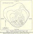
Historical maps

Map from 1889
Map from 1928


See also
swell
- ↑ Article on the Haapai archipelago in the Encyclopædia Britannica
- ↑ a b J. Edward Hoffmeister, Harry S. Ladd & Harold L. Alling: Falcon Island; in: American Journal of Science , December 1929, pp. 461-471
- ↑ The Sydney Morning Herald of November 12, 1927, p. 13: "Falcon Island - A Phenomenon of the Sea."
- ^ New York Times v. September 11, 1898, p. 13: "Falcon Island Has Disappeared"
- ↑ Fonuafoʻou in the Global Volcanism Program of the Smithsonian Institution (English)
- ↑ Fonuafoʻou in the Global Volcanism Program of the Smithsonian Institution (English)
- ^ JJ Lister: A Visit to the Newly Emerged Falcon Island, Tonga Group, South Pacific ; in: Proceedings of the Royal Geographical Society and Monthly Record of Geography, March 1890, pp. 157-160
- ^ Henry Stommel: Lost Islands - The Story of Islands That Have Vanished from Nautical Charts. The University of British Columbia Press, Vancouver 1984, ISBN 978-0-48678467-0 , p. 69
Web links
- Fonuafoʻou in the Global Volcanism Program of the Smithsonian Institution (English)
- ava.jpl.nasa.gov: NASA satellite images of Falcon Island