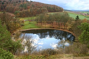
Frickenhauser lake
| Frickenhauser lake | ||
|---|---|---|

|
||
| Frickenhäuser See in autumn, seen from above the shell limestone steep slope on the northeast bank | ||
| Geographical location | District of Rhön-Grabfeld near a district of Mellrichstadt | |
| Places on the shore | Frickenhausen | |
| Data | ||
| Coordinates | 50 ° 24 '11 " N , 10 ° 14' 14" E | |
|
|
||
| Altitude above sea level | 332 m above sea level NN | |
| surface | 0.011 km 2 | |
| length | 0.10 km | |
| width | 0.10 km | |
| scope | 0.31 km | |
| Maximum depth | 28 m | |
|
particularities |
Water-filled collapse depression |
|
The Frickenhäuser See in the Rhön-Grabfeld district near the Mellrichstadt - Frickenhausen district is the largest natural lake in Lower Franconia . It has an area of 11,000 square meters (1.1 hectares), a maximum water depth of 28 meters and, as a special feature, due to its formation, no above-ground inflows or outflows.
The Frickenhäuser See is a natural monument, which is used by the local population as a leisure and recreation area. Every year, the Frickenhäuser Seefest including fireworks takes place at the Frickenhäuser See .
geology
The almost circular lake is located in Triassic rocks of the eastern Rhön foothills, in the northernmost part of the southern German layer level country . The deepening of the terrain in which the lake has formed is a collapsed subterranean cavity ( sinkhole ) created by the washing away of water-soluble rock ( subrosion ). The fact that water remains there is probably due to the fact that the bottom of the sinkhole was subsequently sealed naturally downwards. It is not known whether the lake is fed exclusively by surface water or whether it also has underground tributaries.
The lake lies on a northwest-southeast trending fault , which belongs to the so-called hay litter fault zone . At this fault, Upper Buntsandstein (Röt) in the southwest is pushed up against Lower Muschelkalk ("Wellenkalk", Jena formation) in the northeast. The hay litter fault zone is due to the long-range effects of the formation of the Alps ( Saxon clod tectonics ).
The Frickenhäuser Lake is thus half in the lower shell (in the steep wall at the northeast shore of the lake pending ), so it is obvious that the cavity is formed in the corresponding limestones. However, it cannot be ruled out that the sinkhole formation originated in the somewhat greater depths of the plaster of paris or rock salt deposits of the Werra series of the Zechstein series, some of which are much more easily soluble .
The lake is designated as a protected geotope by the Bavarian State Office for the Environment and is one of the 100 most beautiful geotopes in Bavaria (see also the list of geotopes in the Rhön-Grabfeld district ).
See also
Individual evidence
- ^ Bavarian State Office for the Environment: Frickenhäuser See. Geotope register Bavaria ( online PDF, 138 kB)
- ↑ Frickenhäuser See in the section "Bavaria's most beautiful geotopes" on the homepage of the Bavarian State Office for the Environment
Web links
- Frickenhäuser See on the homepage of Mellrichstadt
