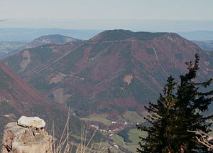
Friesling
| Friesling | ||
|---|---|---|
|
The Friesling from the south |
||
| height | 1340 m above sea level A. | |
| location | Lower Austria , Austria | |
| Mountains | Ybbstal Alps , Northern Limestone Alps | |
| Dominance | 3.5 km → Oisberg | |
| Notch height | 641 m ↓ Pfaffenschlag | |
| Coordinates | 47 ° 51 '44 " N , 14 ° 53' 29" E | |
|
|
||
| Type | Plateau mountain | |
| rock | Limestone, dolomite | |
| Age of the rock | Upper Triassic | |
The Friesling is a 1340 m high mountain in the Ybbstal Alps in the federal state of Lower Austria .
The mountain to the northeast of St. Georgen am Reith is largely forested on its flanks and has an undulating karst plateau about 1000 by 600 meters in size , which is partly free of trees. Geologically, the Friesling is built up mainly from Noric main dolomite on its flanks , which merges into Rhaetian plate limestone towards the summit . At the south-western foot of the mountain near St. Georgen am Reith is the Reithbach spring , a karst spring where up to 15,421 liters of water per second was measured. The 4,024 meter long Friesling tunnel of the Opponitz power station runs under the Friesling .
The mountain can be reached from the saddle of the Großer Kripp , which separates the Friesling from the Oisberg , in about an hour and a half on foot via steep trails or partly via forest roads.
Individual evidence
- ^ Geological map of the Republic of Austria 1: 50,000, sheet 71, Ybbsitz, published by the Federal Geological Institute, Vienna 1988.
- ↑ Source measuring point poster for the event "10 Years of Source Monitoring in the Hydrographic Service" PDF file ; Retrieved September 28, 2009.

