
Gahns
| Gahns | ||
|---|---|---|
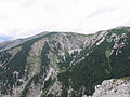
 Gahns seen from the Schneeberg |
||
| Highest peak | Schwarzenberg ( 1352 m above sea level ) | |
| location | Lower Austria | |
| part of | Rax-Schneeberg Group , Northern Limestone Alps | |
|
||
| Coordinates | 47 ° 42 '57 " N , 15 ° 53' 21" E | |
| rock |
Gutensteiner Kalk Reifling Formation Steinalmkalk Wettersteinkalk |
|

The Gahns is the southeastern foothill plateau of the Schneeberg in Lower Austria .
location
The Gahns covers an area of approx. 2150 hectares. Most of the mountain is forested, except for the large meadows. The largest of them is the Bodenwiese with an area of 97 hectares; it is also the largest alpine pasture in Lower Austria. Between Gahns and Hochschneeberg lies the Krummbachstein to the northwest , 1602 m . It is not far from the Gahns, on it is the highest alpine pasture in the area, the Alpl.
The plateau is in the municipality of Bürg-Vöstenhof , the southern roofs (Gahnsleiten) are in Prigglitz , Payerbach and Reichenau an der Rax , the northern flank in Puchberg am Schneeberg .

View of the Gahns of Tannschach

Schwarzenberg (Gahnsgipfel)

View of the Alpl from the Lärchbaumriegel

View of the Schneeberg from the Saurüssel
View of the Schneeberg from the Krummbachstein


The Gahnsgipfel
- Schwarzenberg 1352 m above sea level A.
- Saurüssel 1340 m above sea level A.
- Lärchbaumriegel 1315 m above sea level A.
ways
The Gahns is a popular hiking area. There are numerous climbs:
- from Payerbach via the Gasthof Hochberger to the Bodenwiese
- from Reichenau an der Rax over the Saurüssel to the Bodenwiese
- from St. Christof to the Bodenwiese
- from Kaiserbrunn to the Knofeleben
- through the Eng on the Knofeleben
- from Prigglitz over the dogwood to the Bodenwiese
- from Bürg-Vöstenhof over the large forest meadow to the Bodenwiese
On its north side, the Gadenweither gorge , in which the Johannesquelle lies, leads to Gadenweith .
There are also numerous hiking trails on the Gahns from the Schneeberg.
Refuges
- Naturfreundehaus Knofeleben : on the Knofeleben
- Waldburgangerhütte : on the Bodenwiese
- Pottschacher Hütte : on the dogwood