Gaissa
| Gaissa | ||
|
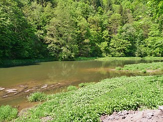
The Gaißa in the Gaißatal landscape protection area |
||
| Data | ||
| Water code | EN : 176 | |
| location | Lower Bavaria | |
| River system | Danube | |
| Drain over | Danube → Black Sea | |
| origin | Confluence of the Großer and Kleiner Ohe near Aicha vorm Wald 48 ° 40 ′ 38 ″ N , 13 ° 17 ′ 2 ″ E |
|
| Source height | 348 m above sea level NN | |
| muzzle | at Passau-Schalding in the Danube Coordinates: 48 ° 35 '55 " N , 13 ° 22' 35" E 48 ° 35 '55 " N , 13 ° 22' 35" E |
|
| Mouth height | approx. 300 m above sea level NN | |
| Height difference | approx. 48 m | |
| Bottom slope | approx. 2.4 ‰ | |
| length | 19.9 km from the confluence of the Große / Kleine Ohe |
|
| Catchment area | 221.85 km² | |
| Discharge at the Hörmannsberg A Eo gauge : 211 km² Location: 5.1 km above the mouth |
NNQ (04.08.1964) MNQ 1958–2006 MQ 1958–2006 Mq 1958–2006 MHQ 1958–2006 HHQ (01.02.1985) |
240 l / s 718 l / s 3.3 m³ / s 15.6 l / (s km²) 51.5 m³ / s 139 m³ / s |
| Medium-sized cities | Passau | |
| Communities | Aicha in front of the forest , Tiefenbach | |
The Gaißa is a left tributary of the Danube in Lower Bavaria .
course
Its two source rivers are called, just like those of the not far away Ilz , Große Ohe ( GEWKZ : 176; right upper course) and Kleine Ohe (GEWKZ: 1764; left upper course) and should not be confused with those namesake. These unite at Aicha vorm Wald to form the Gaißa, which from there flows in a sinuous south-easterly direction to the Danube. It flows east of Passau-Schalding and thus a few kilometers northwest of the central city of Passau . From the confluence of the river, the Gaißa is almost 20 km long, on the main strand from the source of the highest upper course of the Große Ohe it is 46 km. It drains a catchment area of around 222 km².
The lower course of the water was at times heavily polluted by the nearby motorway, meanwhile the water quality class has leveled off at II.
Tributaries
From the confluence to the mouth. Selection.
- Big Ohe , right upper course
- Kleine Ohe , left upper course
- Gotthollinger Bach, from the right
- Uhlersbach
- Rötzinger Bach, from the right
- Hühnerbach, from the left
- Minsinger Bach, from left (previously several section names)
- Bodertinger Bach, from the right
- Tälchenbach, from the right
- Haselbach, from the left
Individual evidence
- ↑ Length (relevant sections of key figure level 4 added, pages No. 106, 111 and 117) according to: Directory of stream and river areas in Bavaria - Isar to Inn river area of the Bavarian State Office for the Environment, as of 2016 (PDF; 3.3 MB)
- ↑ Length of the main line according to: Directory of stream and river areas in Bavaria - Isar to Inn river area, page 92 of the Bavarian State Office for the Environment, as of 2016 (PDF; 3.3 MB)
- ↑ Catchment area according to: Directory of brook and river areas in Bavaria - Isar to Inn river area, page 92 of the Bavarian State Office for the Environment, as of 2016 (PDF; 3.3 MB)
- ^ German Hydrological Yearbook Danube Region 2006 Bavarian State Office for the Environment, p. 217, accessed on October 4, 2017, at: bestellen.bayern.de (PDF, German, 24.2 MB).
