Galgenberg (Leipzig / Markkleeberg)
The Galgenberg is a flat elevation on the border between Leipzig and Markkleeberg . It is 162.6 m above sea level. NHN also the highest natural elevation in the Leipzig city area.
location
The Galgenberg is located in the southeast of Leipzig in the areas of the Leipzig district Liebertwolkwitz and the Markkleeberg district Wachau . The border between the city and the district of Leipzig runs over it . The state road S 46 crosses the low S 242 , the feeder to the A 38 motorway . The Leipzig part of the Galgenberg came in 1999 with the incorporation of Liebertwolkwitz to Leipzig, the part belonging to Wachau was incorporated into Markkleeberg in 1994.
history
According to its name, the Galgenberg, like many other gallows in Germany, was a place for the execution of convicts in earlier times .
Battle of Nations
The Galgenberg gained special importance with the Battle of the Nations near Leipzig in October 1813. In preparation for the clashes, the French army had positioned their artillery on the Galgenberg and used them in connection with the cavalry battle near Liebertwolkwitz on October 14th, 1813. Behind the The battle line-up was prepared for October 16, 1813 to protect the Galgenberg from view. On that day Napoleon had his command post here on the Gallows Hill. Although no decision was made on that day, it remained the southernmost point he reached in the Leipzig Battle of the Nations. His next command post was on October 18 at the Quandtschen Tabaksmühle , before he had to leave Leipzig entirely a day later. On October 18, 1813, the three monarchs were already on the Gallows Hill before they took up their position on the Monarch Hill.
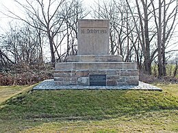
To commemorate the events of the Battle of Nations, the Leipzig “Association for the Celebration of October 19th” erected a memorial on the Galgenberg south of the street in the Wachau corridor in 1852 . It is a stone block resting on a stepped base with the inscription “16. October 1813 ". A plaque attached later on the base announces: “Battle of Wachau, the command post of Emperor Napoleon I”. On the back of the monument, on a small white marble slab, there is only: “Job 38:11”. This reference refers to the quotation from the Bible: “You should come this far and no further; here shall your proud waves lay down! ” (Job 38:11) , which refers to the halt that Napoleon was commanded here.
Triangulation
In the years 1862 to 1890, a state survey , the Royal Saxon Triangulation, was carried out in the Kingdom of Saxony , which was considered one of the most progressive in Europe due to its close-knit network of measuring points. The Galgenberg was the 2nd order station No. 114 ("Station Wachau", 1876). A column made of Rochlitz porphyry still reminds of this action.
Water supply
A large underground elevated tank with a total tank volume of 15,000 m³ was created on the Galgenberg in the Leipzig drinking water network from 1955 to 1958 . This stabilizes the drinking water supply in Leipzig as a buffer storage at particularly high demand or is used for emergency operation, for example in the event of a power failure in the water supply system of the Leipzig municipal waterworks in Probstheida.
Individual evidence
- ↑ Map services of the Federal Agency for Nature Conservation ( information )
- ↑ Statistical Yearbook Leipzig 2015 p. 7
- ^ Website on the Battle of the Nations
- ↑ Reinhard Münch: Landmarks and monuments of the Battle of Nations in and around Leipzig. Barthel, Panitzsch 2000, ISBN 3-910188-28-1 , p. 57
- ↑ Communication from the Leipzig municipal waterworks
Coordinates: 51 ° 17 ' N , 12 ° 27' E


