
Gaspar Grande
| Gaspar Grande | ||
|---|---|---|
 |
||
| Waters | Gulf of Pariah | |
| Archipelago | Bocas Islands | |
| Geographical location | 10 ° 40 ′ N , 61 ° 39 ′ W | |
|
||
| length | 2.4 km | |
| width | 0.8 km | |
| surface | 1.29 km² | |
| Highest elevation | 121 m | |

Gaspar Grande , also known as Gasparee , is an island belonging to Trinidad and Tobago and belongs to the group of Bocas Islands . Administratively, Gaspar Grande belongs to the Diego Martin region .
geography
The archipelago of the Bocas Islands is in front of the northwestern tip of Trinidad, Chaguaramas . While Chacachacare , Huevos and Monos are located in the Dragon's Mouth Strait (Bocas del Dragón), which separates the northwestern tip of Trinidad from Venezuela, Gaspar Grande is further southeast in the Gulf of Paria , just under a kilometer from the Trinidadian mainland (Staubles in the north, the Point Gourd peninsula to the east).
The island consists primarily of limestone with calcite inclusions, some of which have been washed out over the millennia. As a result, the island has numerous cave systems, the most famous of which are the 35-meter-deep Gasparee Caves in the west of the island, which house bats and in which there is an underground freshwater lake, the Blue Grotto. Other cave systems are the White Cave and the Precipice Cavern. There are iron and fluorite deposits, but their exploitation never got beyond preliminary work.
history
In the 17th century the strategically located island was used by pirates as a base. In 1783 it was transferred from the then Spanish governor José María Chacón to the French Gaspar de Percin Roque, who presumably came from St. Vincent and after whom the island is named: In Patois the island was called "Gaspar Ile" (Gaspar's Island), from which im Over time "Gasparee" became. The origin of the official island name "Gaspar Grande" is unknown, a name for the purpose of differentiation from the offshore, much smaller island Little Gasparee (which de Percin never belonged to) is sometimes claimed. De Percin grew cotton on the island. That was highly profitable for a few years, but in 1787 the business was ruined by a cotton boll beetle plague. In 1796 a part in the east of the island was confiscated by the Spaniards in order to build a fort to protect it against the English, which was completed in early 1797 and housed a dozen cannons and four mortars . Due to the fact that Trinidad was handed over to the British without a fight, there was never an operation, today only the foundation walls of a signal tower and a furnace as well as the structure of a circular ditch around the site with a diameter of 40 meters have been preserved. The British built a new fort near the Spanish construction in 1803, fearing attacks by the Spaniards and French, who were at the time warring. Today only the foundation walls of a crescent-shaped jump and that of a 20 × 8 meter barrack remain. On the eastern shore of the island, the British expanded the work begun by the Spaniards into another, small fort, of which only part of the foundation walls are preserved today. In 1826 de Percin sold over 20 hectares of land in the west of the island to the retired captain CA White, who built a whaling station there, the area of which has since been known as Point Baleine. A luxury hotel was built there at the end of the 19th century. Gradually, the heirs of de Percins sold other parts of the island, so that during the whaling boom between 1826 and the end of the 19th century, more stations were created; From around 1870 the first parcels were sold to wealthy Trinidadians who built weekend houses there. Gaspar Grande became relatively popular as a vacation spot; An example of a prominent visitor from this period is Noël Coward , who composed the song "The Road to Mandalay" on the island. During the Second World War , a battery with two guns was installed on Gaspar Grande ; In Point Baleine there were also barracks for 130 (British) soldiers. The facility was never used. Today the island serves as a refuge for wealthy mainland Trinidadians, with a few holiday homes dating from the late 19th century. Tourism plays a modest role; the state Chaguaramas Development Authority offers tours to the Gasparee Caves, which have been open to the public since 1981, and keeps the infrastructure required for this intact.

Remains of the British fort
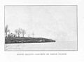
Pointe Baleine, Gaspar Grande, 1910


Flora and fauna
.jpg)
Rain clouds hit Trinidad mostly from the northeast, from the Atlantic, so that the Bocas Islands have a drier climate than the mainland and are largely covered by dry forest. Bursera simaruba , Carnegiea gigantea , Eugenia ligustrina, Prunus rivularis, pork plum trees (Spondias mombin) and Tabebuia serratifolia grow on the island .
A good dozen species of snakes live on the island, including the idol snake , Epicrates maurus, Mussuranas and Sibon nebulatus. Lizards are also represented numerous, colored iguanas , Green Iguana or Thecadactylus rapicauda. The animals native to the island also include the Brazilian giant runner , the big hare's mouth and the rare Amazon oratrix.
Individual evidence
- ↑ Anthony de Verteuil: Western Isles of Trinidad, p. 74. Paria Publishing, 3rd edition 2011.
- ^ Caribbean History Archives. Retrieved May 23, 2015 .
- ^ Anthony de Verteuil: Western Isles of Trinidad, p. 69.
- ↑ a b Newsday article from May 22, 2005, available online
- ^ Anthony de Verteuil: Western Isles of Trinidad, p. 71.
- ^ Michael Goldberg Collection of the UWI. Retrieved May 23, 2015 .
- ^ Anthony de Verteuil: Western Isles of Trinidad, p. 78.