Gaya tumuli
Gaya-Tumuli is the title of a proposal by South Korea for inclusion in UNESCO World Heritage .
background
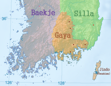
At the time of the Three Kingdoms , the Korean Peninsula was essentially divided between the three kingdoms of Goguryeo in the north, Baekje in the southwest, and Silla in the southeast. In the far south, however, there was also a confederation of smaller kingdoms called Gaya . This confederation was wedged between the states of Baekje and Silla on the lower reaches of the Nakdonggang in the central south of the Korean Peninsula.
The small states , the Gaya confederacy formed, went to the first centuries after Christ from the chiefdoms of Byeonhan out that after the fall of the Kingdom of Jin-guk in the 2nd century. One of the three confederations of the Samhan period in southern Korea. According to legend, the confederation was formed by six states whose kings were born from six eggs that had come down from heaven. The number and naming of the communities that made up the confederation fluctuates in the literature.
First , Geumgwan Gaya , located in the area of today's city of Gimhae , took over the leadership of the confederation, later this role was passed on to Dae Gaya . The individual communities practiced a lively exchange of goods with one another and with foreign countries via a network of trade routes. In the course of the sixth century Gaya was conquered by Silla, Geumgwan Gaya as early as 532 AD, subsequently the rest of Gayas with Dae Gaya until 562 AD.
Throughout the existence of the Gaya Confederation, important personalities were buried in burial mounds. In the 1st and 2nd centuries mainly wooden coffins were buried in it. Graves for rulers and subjects were usually in a single area. In the case of graves for the ruling classes, grave goods were given in a hole under the coffin. In the 3rd and 4th centuries the burial mounds increasingly contained wooden burial chambers. Rulers' tombs were erected on top of hills at a distance from the graves of their subjects. In addition to grave goods, they also contain human and animal sacrifices. The construction of stone burial chambers began in the 5th century. The arrangement of the graves showed more and more the increasing separation between the ruling classes and the different hierarchical levels. Particularly large burial mounds from the late 5th century testify to the increasing supremacy of Dae Gaya and the efforts to form a centralized state. The conquest of Gaya by Silla put an end to this.
So far, around 780 grave mound clusters from the Gaya period have been identified by means of soil surveys. 104 of them have been extensively examined archaeologically. As a result of this research, 20 of them were included in national or local cultural heritage lists because of their importance as evidence of the culture and history of Gaya.
World Heritage candidate
As of 2015, each of the three kingdoms of Korea and each of its successor states Goryeo and Joseon was represented by World Heritage Sites. In 2019, South Korea added the Gaya-Tumuli historical sites of the Gaya Confederation to its list of proposals in order to pay tribute to these predecessor states of today's Korea.
In order to justify the outstanding universal meaning, among other things, the following is given:
“Due to the geographical location, the predominant types and the spatial arrangement of the individual graves and their changes over time, the Gaya burial mounds offer an exceptional testimony to the entirety of the Gaya culture from its origin and development to its demise as well as for the political identity of the Gaya Confederation as a whole ... These graves promote a holistic understanding of the old Korean Federation of Gaya. "
The aim is to be entered in the World Heritage List based on the World Heritage criterion (iii):
“The complex consists of seven burial mounds, the construction of which was carried out in around 600 years, spanning the entire history of the Gaya Confederation from the beginning of the common era to the fall of Dae Gaya in 562. As an amalgamation of different political communities, Gaya maintained a systematic trade network that included extensive routes by sea, rivers and land. The diverse communities that made up the confederation developed through the exchange of influences as politically equals along this trade network. The complex testifies to this unique social and political network that defined the Gaya Confederation. "
scope
The serial proposal includes seven groups of burial mounds in the south-central part of the Korean Peninsula. These were selected from the 20 grave mound clusters of the Gaya period entered in cultural heritage lists,
- whether they bear witness to the social and political development process of the Gaya Confederation through their spatial arrangement of graves for the different social classes and through temporal changes in the types of graves,
- whether they were built in the central areas of the respective main cultural regions of Gaya and
- whether they serve as a testimony to the Gaya Confederation's systematic trading network.
| designation | City / County Province |
Tumuli | Remarks | image |
|---|---|---|---|---|
| Daeseong-dong tumuli |
Gimhae -si Gyeongsangnam-do ( location ) |
219 | Central burial place of Geumgwan Gaya , the initially leading and most eastern community of Gaya
Several hundred graves in an area 300 meters long and 100 meters wide, 219 of which have been excavated. |
 ( more pictures ) |
| Marisan tumuli |
Haman- gun Gyeongsangnam-do ( location ) |
127 | Central burial place of Ara Gaya on a two kilometer long hill near the confluence of the Namgang and the Nakdonggang . |
 ( more pictures ) |
| Okjeon tumuli |
Hapcheon- gun Gyeongsangnam-do ( location ) |
28 | Central burial place of Darakguk , a regional trading center in the northern part of the Confederation, on a hill on the Hwanggang, a tributary of the Nakdonggang. |
 ( more pictures ) |
| Jisan-dong tumuli |
Goryeong- gun Gyeongsangbuk-do ( location ) |
> 700 | Central burial place of Dae Gaya in the north of the Confederation in the late 5th and early 6th centuries.
Largest grave mound cluster in Gaya on a 2.4 kilometer long and one kilometer wide area. |
 ( more pictures ) |
| Songhak-dong tumuli |
Goseong -gun Gyeongsangnam-do ( Layer 1 , Layer 2 , Layer 3 , Layer 4 , Layer 5 , Layer 6 ) |
15th | Central burial place of So Gaya near the south coast of Korea. |

|
| Gyo-dong and Songhyeon-dong tumuli |
Changnyeong -gun Gyeongsangnam-do ( Layer 1 , Layer 2 , Layer 3 ) |
> 320 | Central burial place of Bihwa Gaya , which played a leading role in the trade with Silla due to its location on the east bank of the Nakdonggang. |
 ( more pictures ) |
| Yugok-ri and Durak-ri tumuli |
Namwon -si Jeollabuk-do ( location ) |
> 40 | Central burial place of Gimunguk , the westernmost community of Gaya |
 ( more pictures ) |
Web links
- Gaya Tumuli on the website of the UNESCO World Heritage Center for tentative lists.


