Gilf el-Kebir
Coordinates: 23 ° 26 ' N , 25 ° 50' E
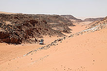
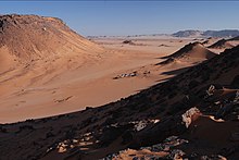
The Gilf el-Kebir (also The Great Barrier ; Arabic الجلف الكبير, DMG al-Ǧilfu l-kabīr ) is a sandstone- encased basalt high plateau in the extreme southwest of Egypt on the border with Libya . The deserted area rises about 300 meters above the surrounding desert and extends over 15,770 square kilometers. The Gilf el-Kebir consists of two parts, the Abu-Ras plateau in the northwest and the Kamal-al-Din plateau in the southeast. The plateaus are separated by the 'Aqaba Pass and the Wada' Assib. In the southeast of the plateau, massive rock formations and deeply cut wadis dominate . The northern part of the plateau is much more rugged, which is due to the draining forces of the sand of the Great Sand Sea to the north . The wadis are particularly wide here.
The Gilf el-Kebir impresses with its rugged scenery, its remoteness and its geological significance. The area is characterized by volcanism , tectonics and erosion . During the wet phases of the Sahara there were forests and cattle nomads . Various stone tools that can still be found today were used for hunting. Mighty rivers once drained from the plateau through long wadis into the plains. A aridity of the region did not begin until late.
Administratively, the area, like the entire uninhabited southwest of Egypt, belongs to the district ( markaz ) Dachla of the governorate ( mu dāfaẓat ) al-Wadi al-dschadid (translated New Valley ).
history
In prehistoric times the wadis of Gilf el-Kebir were still populated.
History of exploration
The mountain formations of the Gilf el-Kebir were first noticed by the researcher WJ Harding-King in 1909 and 1911.
In 1917, desert explorer John Ball saw the region. He was followed in 1918 by a certain Lieutenant Moore.
The first partial mapping took place in 1923–1926 by the Egyptian researcher Prince Kamal al-Din Hussein .
The Hungarian Saharan explorer and explorer Ladislaus Eduard Almásy explored various vegetation-rich wadis of the plateau together with three Britons, Sir Robert Clayton-East-Clayton, commander Hubert Jones Penderel and the surveyor Patrick Clayton in 1932/1933, the exploration of which later attracted other research groups . Almásy also found the prehistoric rock carvings of mammals and swimming people in 1933. During the first exploratory flights, the expedition members Sir Robert Clayton-East-Clayton and Hubert Jones Penderel were able to see almost round, crater-like hills, the character of which can only be seen from the air, the so-called Clayton craters (N25 ° 22 'E25 ° 24' and N22 ° 30 'E25 ° 54'). The craters are of volcanic origin.
In 1938, the British engineer and Sahara crosser Ralph Alger Bagnold surveyed the area. The founder and first commander of the Long Range Desert Group of the British Army in World War II was supported and equipped by the Royal Geographical Society , a learned society of which he was a member. It had set itself the task of “exploring the mineral structure of the earth”.
The remoteness of the region only allowed the map series to be completed in the 1970s. When NASA was also looking for a landscape on earth that could be compared to the photos of Mars made for scientific purposes, it was found that the Gilf el-Kebir came closest to these expectations. Maps for the Russian military were created in 1977 on the basis of satellite images.
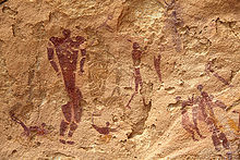
In 2002 the Italian Jacopo Foggini discovered a rock overhang, which was named Foggini-Mestekawi Cave after him, but was better known as the New Cave or Cave of the Beasts . It is the largest cave in Gilf el-Kebir with rock paintings. Depictions include hunting scenes, animals like giraffes, ibex, and gazelles, and several headless animal figures - possibly mythical beings. The performances of hand outlines stretch over the entire wall area.
Petroglyphs
The most famous prehistoric rock paintings and engravings can be found in Wadi Sura . Particularly spectacular are the cave of the beasts and the cave of the swimmers . The latter was discovered by the researcher Ladislaus Almásy (alienated today, but better known as The English Patient, based on a novella by the Canadian novelist Michael Ondaatje ). Mostly people are represented. Some of these people seem to swim (in groups), which suggests the earlier high fertility of the region and lake landscapes. Other motifs are giraffes, ostriches and dogs.
The wadis
The wadis of Gilf el-Kebir are many and varied.
- A particularly impressive wadi is the Wadi Hamra (= Red Valley), which with its red sand contrasts with the black rocky landscape. The wadi cuts deep into the high plateau and is divided into three separate valleys in a north-easterly direction. There are also acacias and at least three petroglyphs . One of them most likely shows three rhinos . The wadi was still green in the 1930s , and the Tebu Beduins were able to graze their animals there, for example camels and cattle.
- In Wadi Sura, also Wadi Sora (Valley of Images) (وادي صورة) are the cave of swimmers and the cave of archers .
- Nearby is the Cave of Beasts (Foggini-Mistikawi Cave) , which was only discovered in 2002 .
- In Wadi Abd al-Malik vegetation is found.
- Remains of trucks and cars of the Long Range Desert Group as well as an abandoned army truck from the Second World War (the latter today in the Al Alamein Museum) are impressive in Wadi Dayyiq (وادى الضيق).
- Other wadis in the Kamal-ed-Din plateau are the Wadi al-Bacht (وادى البخت) and the Wadi Wasʿ (وادى واسع).
Other wadis in the Kamal-ed-Din plateau:
- Wadi al-Achdar وادى الأخضر
- Wadi Firaq وادى فراق
- Wadi al-Gazayir وادى الجزائر
- Wadi Maftuh وادى مفتوح
- Wadi Maschi وادى مشى
The traditional entrance to the plateau is about the nearly 60 km east of the Wadi Sura located Aqaba Pass mastered (N23 ° 24.46 'E25 ° 41.91'). The pass was discovered by Penderel in 1932 and named "Gap". Almásy is the origin of the name 'Aqaba Pass "steep ascent". Wadi 'Abd el-Malik or Wadi Hamra to the north are considered departures .
Gilf el Kebir National Park
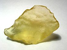
The Gilf el-Kebir high plateau is part of the national park of the same name, which also includes the Great Sand Sea , the Jabal Arkanu massif and the Gabal Uwainat massif . The silica glass field lies in the great sea of sand . Here you can find the unique Libyan desert glass , the origin of which is still controversial. Both a meteorite impact ( impactite glass), of which there are no traces, and a hydrovolcanic explosion in which SiO 2 gel reached the surface of the earth were discussed. The 1934 meter high Gabal Uwainat is primarily located on the Sudanese and Libyan border terrain . In total, the park covers an area of 48,523 square kilometers.
literature
- Ladislaus E. Almásy: Swimmers in the desert: in search of the Zarzura oasis . 3. Edition. Haymon, Innsbruck 1997, ISBN 978-3-85218-248-3 .
- Stefan Kröpelin: Suggesting Natural Heritage Sites in Remote Desert Areas . Egyptian National Commission for UNESCO, Cairo 1996. [1]
- Alberto Siliotti: Gilf Kebir National Park . Geodia, Verona 2009, ISBN 978-88-87177-86-2 .
Web links
- Reinhart Mazur: Silica Glasfeld and Wadi Sura
- András Zboray: Rock Art Documentation Project
Individual evidence
- ↑ Alberto Siliotti: Oases of Egypt: Map of the Western Desert . 2nd Edition. Geodia, Verona 2009, ISBN 978-88-87177-76-3 , p. 14 .
- ↑ Alberto Siliotti: Oases of Egypt: Map of the Western Desert . 2nd Edition. Geodia, Verona 2009, ISBN 978-88-87177-76-3 (first edition: 2007).
- ^ WJ Harding King: Travels in the Libyan Desert . In: The Geographical Journal (GJ) . tape 39 , 1912, ISSN 1475-4959 , pp. 133-137, 192 .
- ↑ HWGJ Penderel: The Gilf Kebir . In: The Geographical Journal (GJ) . tape 83 , 1934, ISSN 1475-4959 , pp. 449-456 .
- ↑ Kemal el-Dine, Prince Hussein: L'exploration du Désert Libyque . In: La geographie / Société de Géographie . tape 50 , 1928, ISSN 0001-5687 , pp. 171-183, 320-336 .
- ↑ Ladislaus E. Almásy: Swimmers in the desert: in search of the Zarzura oasis . 3. Edition. Haymon, Innsbruck 1997, ISBN 978-3-85218-248-3 .
- ↑ Ladislaus E. Almásy: Swimmers in the desert: in search of the Zarzura oasis . 3. Edition. Haymon, Innsbruck 1997, ISBN 978-3-85218-248-3 , pp. 132 f., 218 f . (On page 211 there is a note that Almásy suspected different climatic conditions in the Holocene even then, although the Hungarian Geographical Society did not agree with this theory at that time).
- ↑ Kenneth Stuart Sandford: Vulcanic Craters in the Libyan Desert . In: Nature . tape 131 , 1933, ISSN 1476-4687 , pp. 46-47 .
- ↑ Kenneth Stuart Sandford: Geological Observations on the Northwest Frontiers of the Anglo-Egyptian Sudan and the adjoining part of the Southern Libyan Desert . In: The quarterly journal of the Geological Society of London . tape 91 , 1935, ISSN 0370-291X , p. 323-381 .
- ^ Norbert Bruges: Remarks on the origin of the crater-shaped structures around Gilf Kebir and Djebel Uweinat (Egypt) .
- ↑ a b R.A. Bagnold, OH Myers, RF Peel, HA Winkler: An Expedition to the Gilf Kebir and 'Uweinat, 1938 . In: The Geographic Journal (GJ) . tape 93 , no. 4 , 1939, ISSN 1475-4959 , pp. 281-313 .
- ↑ Alberto Siliotti: Oases of Egypt: Map of the Western Desert . 2nd Edition. Geodia, Verona 2009, ISBN 978-88-87177-76-3 , p. 17 .
- ↑ These are the General Staff map sheets G-35-26, G-35-27, G-35-32, G-35-33, F-35-02, F-35-03, F-35-08 and F-35-09 on a scale of 1: 200,000. The material used for this is from 1972.
- ↑ Egypt: In the cave of the beasts . In: Spectrum of Science; Special 2/2011: Under the Spell of the Desert , 2011, pp. 6–13.
- ^ Grotta Foggini , the website of the cave from its discoverers Jacopo and Massimo Foggini.
- ↑ Alberto Siliotti: Oases of Egypt: Map of the Western Desert . 2nd Edition. Geodia, Verona 2009, ISBN 978-88-87177-76-3 , p. 22nd f .
- ↑ Hans Rhotert: Libyan rock paintings: Results of the 11th and 12th German inner-African research expedition (Diafe) 1933/1934/1935 . Wittich, Darmstadt 1952.
- ↑ Jörg Linstädter (ed.): Wadi Bakht: Landscape archeology of a settlement chamber in Gilf Kebir . Heinrich-Barth-Inst., Cologne 2005, ISBN 978-3-927688-25-4 .
- ↑ Werner Schön: Excavations in the Wadi el Akhdar, Gilf Kebir (SW-Egypt) . Heinrich-Barth-Inst., Cologne 1996, ISBN 978-3-927688-12-4 .
- ↑ Ladislaus E. Almásy: Swimmers in the desert: in search of the Zarzura oasis . 3. Edition. Haymon, Innsbruck 1997, ISBN 978-3-85218-248-3 , pp. 121 .
- ↑ Ulrich Jux: Composition and origin of desert glasses from the Great Sand Sea of Egypt . In: Journal of the German Society for Geosciences (ZDGG) . tape 134 , 1983, ISSN 1860-1804 , pp. 521-553, 4 plates .
- ^ Norbert Brügge: The non-impact origin of the Libyan Desert Glass (LDG) .
- ↑ Desert glass and the craters of the Eastern Sahara by Reinhart Mazur.
- ^ Natural Protectorates . Egyptian Environmental Affairs Agency (English).


