Glindowsee
| Glindowsee | ||
|---|---|---|

|
||
| Geographical location | Potsdam-Mittelmark district | |
| Drain | across the Strenggraben to the Havel | |
| Places on the shore | Glindow , Petzow | |
| Data | ||
| Coordinates | 52 ° 21 '17 " N , 12 ° 56' 12" E | |
|
|
||
| surface | 1.95 km² | |
| length | 3.26 km | |
| width | 1 km | |
| volume | 10,000,000 m³ | |
| Maximum depth | 14 m | |
| Middle deep | 5.1 m | |
| Catchment area | 30 km² | |
|
particularities |
one of the cleanest lakes in Brandenburg |
|
The Glindowsee , also colloquially Glindower See , is a lake in the district of Potsdam-Mittelmark in the urban area of Werder (Havel) in Brandenburg . The lake is about 1.95 km² and 3.26 km long. Its widest point is 1000 m.
The Glindowsee (GdS) is a so-called other federal inland waterway and belongs to the Potsdamer Havel , a branch line of the Lower Havel waterway , for which the Brandenburg Waterways and Shipping Office is responsible.
geography
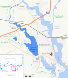
The Glindowsee is located southwest of Werder / Havel starting at the Schwielowsee in a line with the Petzower Haussee, the Großer Plessower See and the now silted Krielower See towards Schmergow almost parallel to the Havel. In the north it has a ditch-like connection with the Great Plessower See, which does not always carry water. At the narrowest dividing point in the east to the Havel, the Strenggraben was dug in 1701 and the Strengbrücke built.
geology
The Glindowsee lies in an Ice Age gully that was formed around 19,000 years ago during the Vistula high glacial . It is separated from the Havel by a ridge consisting of remnants of edged moraines .
Hydromorphology
Water depths, stratification and ecological status
The average water depth of the lake is 5 m, and the deepest point is given as 14 m. The reference state of the lake, i.e. the one it would have without human influence, is assessed as mesotrophic . In 2009 its water was polytrophic , in 2014 it was slightly eutrophic . According to the EU Water Framework Directive , the ecological status of the Glindowsee in 2017 is given on a five-point scale with 5 (= "poor status"; environmental target of the WFD is completely missed). The chemical status is rated with 3 (= "moderate status"; environmental target of the WFD is just missed). In terms of type, it is a lime-rich, stratified lake with a relatively large catchment area and the stratification of the water in different temperature and convection levels. Due to the low proportion of phytoplankton, the visibility depths are more than two meters even in summer .
Lake bottom
The lake bottom is fine sandy to coarse gravel.
Bank area and plants
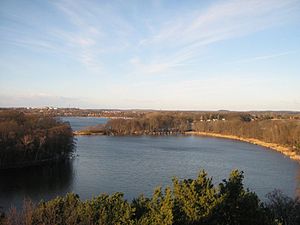
The eastern, gently sloping bank is bordered by a swampy belt of reeds. In front of the lake there is a wide belt of reeds with dense cattail stocks and rush vegetation (Cladium mariscus). In shallow water grows Kalmus . The western bank is steeply sloping and wooded. The lake is built all around.
See also
Web links
- The Glindowsee in the EU Water Framework Directive (PDF file; 243 kB)
Individual evidence
- ↑ a b c d e f g Description of the lakes EC Water Framework Directive: Glindower See . (PDF; 830 kB), State Office for the Environment Brandenburg , Section W14, as of October 10, 2017.
- ↑ is calculated from area and volume, two valid digits
- ^ [1] Directory F of the Chronicle, Federal Waterways and Shipping Administration, accessed on April 14, 2019
- ↑ [2] Directory E, serial no. 60 of the Chronicle, Federal Waterways and Shipping Administration, accessed on April 14, 2019
- ↑ Ordinance on the "Krielower See" nature reserve - Brandenburg regulation system, accessed on April 14, 2019


