Goggeleswehr
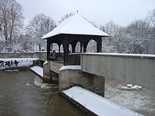
The Goggeleswehr was a weir in the Wertach near Augsburg . It was built over with a bridge, the Goggeles Bridge . The roof of the lock cottage was from a weather vane decorated tin that the weir and the bridge gave its name (on Swabian is Goggele means "chicken" or "tap"). The Goggelesbrücke, which connected Hessenbachstrasse with Holzbachstrasse for pedestrians and cyclists, was part of Augsburg's historical water management system and a landmark of the Pfersee community at the gates of Augsburg.
The weir was used from the late 16th to the early 20th century to operate the Wertach Ablass , the discharge of river water into a stream or canal in the north-west of Augsburg. The weir existed until 2005. It was damaged in a flood and then demolished after it had lost its original purpose through other water measures 85 years earlier.
history
Origin of the weir
In the Middle Ages the Singold still flowed between the Wertach and the city of Augsburg into the Wolfzahnau area . However, there was a strong Wertach flood in 1588, during which the Singold erupted into the Wertach near Göggingen . As a result, their old lower reaches fell dry and the numerous mills there no longer had any water. For this reason, the former Singold-Unterlauf, today's Senkelbach Canal , was given a new passage from the Wertach, the Holzbach, with a new dug in 1589. At this point the Wertach was dammed with the Goggeles weir in order to supply the Holzbach and Senkelbach with water all year round.
Due to the weir, which had been in use for centuries, the Wertach dug itself increasingly deeper on the underwater side towards Oberhausen , so that the weir last spanned a height of 5 meters and created an impressive waterfall.
Creation of the Wertach Canal
In 1920/1921, the technical waterway situation changed: to supply power to the Augsburg tram , the factory canal , which was built near Göggingen in 1884 , was extended and the Wertach canal was created, which runs parallel to the Wertach at the level of Pfersee, but on the eastern (Augsburg) side , operates the Wertach power station there and has since carried most of the Wertach water into this section. Since then, the Holzbach is no longer supplied with water directly from the Wertach, but via the Wertach Canal. The surplus of the Wertach Canal, which is not needed for the Holz and Senkelbach, is returned to the Wertach below the Goggeles weir. The bed of the Wertach carries significantly less water due to the drainage into the canals, but swells all the more noticeably during floods. Despite the changed situation, the Goggeles weir remained as a weir and received its wooden structure.
Popular photo motif
In 1959, a little further north, the four-lane Ackermann Bridge was built over the Wertach, which is part of the Bürgermeister-Ackermann-Straße, a busy arterial road to the west. The Ackermann Bridge offered an excellent view of the underwater side of the 48-meter-wide weir waterfall in the Wertach, which rushed particularly powerfully during floods. With its photogenic bridge, which was used by pedestrians and cyclists, and the “Fischerstuben” restaurant on the upstream bank of Wertach , which still exists today , the Goggeles weir formed a romantic ensemble.
Demolition plans and destruction of the weir
As part of the Wertach Vital project , a long-term plan was to replace the Goggeles weir with a ramp that should limit deep erosion in the river bed and at the same time enable fish to swim against the current. In 2004 the city council decided the controversial demolition of the weir and a replacement building for 1.2 million euros in 2006. Unexpectedly, a flood of the Wertach in 2005 led to a faster implementation of the demolition plan. It washed away the Goggeles weir, so that the damaged weir had to be dismantled in a hurry to prevent it from being torn away and damaging the Ackermann Bridge. The wooden structure of the Goggeles Bridge from 1922 was saved.
Situation today
At the former weir
At the location of the weir, a provisional stone pouring was first erected, and at the end of 2006 a 300 meter long locking ramp made of large stone blocks with a fish ladder was built. The Wertach RV park is now on Holzbachstrasse, the beginning of the former Goggeles Bridge . A new pedestrian and cyclist footbridge on the site of the former Goggeles Bridge was designed as a plan in 2009, but its implementation is still open. The dilapidated Ackermann Bridge was demolished in December 2015 and replaced by a new one.
The pavilion in the zoo
The pavilion-like wooden structure of the Goggeles Bridge, rescued from the floods, is now in the Augsburg Zoo at the seal basin .
Web links
- Goggeles-Bruecke.de , a reminder page for the Goggelesbrücke
- Goggeles Bridge in Augsburgwiki
Individual evidence
- ↑ Press release of November 10, 2007 ( Memento of April 28, 2016 in the Internet Archive ) in the Internet Archive
- ^ Martin Kluger: Historical water management and water art in Augsburg. Canal landscape, water towers, fountain art and water power . 2nd Edition. Context Verlag, Augsburg 2012, ISBN 978-3-939645-50-4 , p. 44 .
- ^ Joachim Gehringer: Events around the Goggeles bridge. Retrieved April 28, 2016 .
- ↑ The days of the Ackermann Bridge are numbered. Augsburger Allgemeine, September 20, 2015, accessed April 28, 2016 .
- ^ Joachim Gehringer: Events around the Goggeles bridge. Retrieved April 28, 2016 .
- ↑ Seals now guard Pfersee's landmarks. Augsburger Allgemeine, July 29, 2010, accessed on May 2, 2016 .
- ↑ New plan to replace the Goggeles Bridge. Augsburger Allgemeine, accessed April 28, 2016 .
- ↑ Ackermannbrücke can be used again. Augsburger Allgemeine, November 24, 2017, accessed on July 1, 2018 .
- ↑ Seals now guard Pfersee's landmarks. Augsburger Allgemeine, July 29, 2010, accessed on May 2, 2016 .
Coordinates: 48 ° 22 ′ 9.8 ″ N , 10 ° 52 ′ 37.2 ″ E


