Wolf toothau
|
Wolf toothau
|
|
|
Today's confluence of Wertach (left) and Lech (right) on the Wolfzahnau |
|
| location | Augsburg , Swabia , Bavaria , Germany |
| surface | 74.14 ha |
| Identifier | LSG-00525.01 |
| WDPA ID | 396058 |
| Geographical location | 48 ° 24 ' N , 10 ° 53' E |
| Setup date | July 30, 1998 |
The Wolfzahnau is a conservation area in the north of Augsburg . It covers 76 hectares.
location
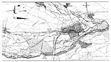
The Wolfzahnau is located in the northern Augsburg urban area in the Augsburg-Rechts der Wertach district between the Oberhausen and Firnhaberau districts . It is bordered on both sides by the two largest rivers in Augsburg, the Wertach and the Lech . At the northern end of the Wolfzahnau, the Wertach flows into the Lech. The area east of the Wertach is bounded by the outlet channel (39 m³ / s), which is created by the confluence of the Stadtbach and Proviantbach . This part is therefore not accessible. The landscape is mainly covered by alluvial forests, which previously dominated large parts of the banks of the Lech and Wertach.
The ordinance of the city of Augsburg of July 30, 1998 names the protection zone as "the headland at the confluence of the Lech and Wertach rivers with the primeval forest-like alluvial forest through which the Stadtbach and Proviantbach flow, including the Lech river bed with its gravel areas ..."
Origin of name
The area had various names until the end of the 19th century, including the name "Wolfszahn" (with Fugen-s ). The inn "zum Wolfszahn" was on top of it. On March 29, 1879, the Augsburg magistrate decided to rename the wasteland after the inn "Wolfzahnau". This took place on May 10, 1879. The addition "Au" refers to the floodplain . The Fugen-s was apparently lost with this official name.
There are hypotheses about the older origin of the name:
- It could be a modified old field name that described the tapering confluence of the Wertach in the Lech as the tooth of a wolf . Today's distinctive shape of a peak has only been clearly pronounced since the two rivers were straightened ; on maps up to the mid-19th century, the area is rich in meandering river curves, side arms and gravel banks.
- Renaissance etymologists wrongly traced the Latin word “Licus” for Lech back to the ancient Greek word “Lykos” (wolf). For this reason, the figure of the river god Lech was given the attribute of a wolf's skin at the Augustusbrunnen in Augsburg .
history
The Wolfzahnau belonged to the Bavarian town of Lechhausen for a long time , which was independent until it was incorporated in 1913. On March 18, 1854, the wooded area was added to the territory of the city of Augsburg.
In the Wolfzahnau was for a long time a "slave driver" ( Skinner ). That is why it was also called "Schinderinsel".
In 1881 the city of Augsburg planned to build a forest cemetery or central cemetery on the Wolfzahnau area . City planning officer Ludwig Leybold presented detailed plans in 1884. The execution would have involved major changes in the landscape, e.g. B. straightening the course of the Lech. In the end, due to nature conservation concerns, the cemetery was not built. The Lech was later massively straightened.
On May 29, 1923, the city of Augsburg exchanged the site for replacement areas on the east side of the Lech with Maschinenfabrik Augsburg-Nürnberg ( MAN ). Today's owners are MAN and Augsburger Localbahn .
In 1970 Berliner Allee was supposed to be extended through Wolfzahnau in four lanes to Donauwörtherstraße, but the project was not implemented.
Decades of planning to turn the area into a public park have not yet been implemented. There were also frequent plans by industrial companies to cut down the Wolfzahnau in order to build there. MAN, located on the southern edge of the Wolfzahnau, had the greatest interest in this.
Wolfzahnau hydropower plant
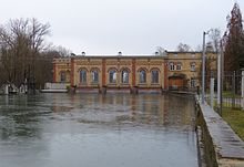
All of Augsburg's Lech canals unite towards the end in a single wide canal that leads to a listed hydroelectric power station built in 1902 .
Wolfzahnauwehr power plant
Up to 35,000 liters of water flow per second in the combined city and provision stream. This is roughly the same amount of water as that flowing past the Lech next to the power plant. In 2007 it was decided to build a second hydropower plant, this time on the Wolfzahnau weir on the Lech, which was built from 2009 to May 2010 on the eastern side of the river together with a fish ladder.
Web links
Individual evidence
- ^ Franz Häussler: When the Wolfzahnau in Augsburg was to become a cemetery. In: augsburger-allgemeine.de. Augsburger Allgemeine, June 1, 2019, accessed on March 12, 2020 .


