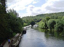
Goring Gap
The Goring Gap is a geological formation on the River Thames approximately 10.5 km upriver from Reading .
background
Half a million years ago the Thames flowed through Oxfordshire as it is today , but then turned northeast and crossed Bedfordshire before reaching the North Sea at East Anglia near Ipswich . During the Elster glaciation , ice blocked the outflow into the sea and meltwater that poured into the Thames built up to form a lake. This lake water eventually cut a new river course through the chalk at what is now Goring Gap. The new course of the river now went south through Berkshire , now Hertfordshire and Essex .
Today the Goring Gap narrows the otherwise wide valley of the Thames. Steep hills rise south to Lardon Chase, the Berkshire Downs and Chiltern Hills rise to the north. The places Goring and Streatley are on the Thames in the Goring Gap.
The Goring Gap is a major transportation route that takes up a main road between Reading and Oxford , as is the main rail line from London - Paddington .
Individual evidence
- ↑ GEOGRAPHY & GEOLOGY at: Visit Goring and Streatley.co.uk
- ↑ The Goring Gap at: Save the Goring Gap.org.uk
Coordinates: 51 ° 31'27.9 " N , 1 ° 8'30.1" W.

