Gründleinsmühle (Castell)
|
Gründleinsmühle
Municipality of Castell
Coordinates: 49 ° 45 ′ 4 ″ N , 10 ° 20 ′ 46 ″ E
|
|
|---|---|
| Height : | 272 m |
| Residents : | 3 (1987) |
| Postal code : | 97355 |
| Area code : | 09325 |
|
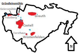
Location of the Gründleinsmühle in the Casteller municipality
|
|
The Gründleinsmühle (also Obere Mühle , Heumühle ) is a wasteland in the area of Castell in the Lower Franconian district of Kitzingen .
Geographical location
The mill is located in the north of the Casteller municipality on the Gründleinsbach, which gives it its name . The municipality of Rüdenhausen begins to the north , the Rüdenhäuser Straße runs past the mill. The Casteller district of Greuth rises to the east , while Castell itself can be found in the south. To the west, also on the Gründleinsbach, is the Geiersmühle and the Casteller district of Trautberg . The Gründleinsloch , a karst spring, is in the immediate vicinity .
history
The mill at Gründleinsbach is one of the oldest watermills in the area. It was first mentioned in 1399 as the "Upper Mill". It probably supplied the grain for the residential town of Castell and was given to various millers by the Counts of Castell as a fief. It was not until the 19th century, 1804, that the then miller Leonhard Dennterlein erected the buildings that are still preserved today.
In 1855, the then pastor of the Johanneskirche in Castell Wilhelm Funk founded an asylum for escaped convicts in the mill's farm buildings. This asylum was expanded by a few buildings in 1930 and 1949. During World War II it was the target of an air raid by British bombers . On April 4, 1945 the farm buildings were destroyed. The reconstruction was carried out in the post-war period.
The Gründleinsmühle remained in operation after the war. Since 1926 it has been owned by Georg Heumüller, who lived in the facility with his family. That is why the name “Heumühle” caught on in the 20th century. In 1985 the mill was stopped and the mill was converted into a residential building .
literature
- Administrative community Wiesentheid (Ed.): Markungsumgang Rüdenhausen September 15, 2001 . Wiesentheid 2001
- Walter Scherzer: A look into history . In: Rudolf Kniewasser (ed.): Castell-Grafschaft and Dean's Office . Erlangen 1991, pp. 19-33
Web links
Individual evidence
- ↑ Bavarian State Office for Statistics and Data Processing (Ed.): Official local directory for Bavaria, territorial status: May 25, 1987 . Issue 450 of the articles on Bavaria's statistics. Munich November 1991, DNB 94240937X , p. 364 ( digitized version ).
- ↑ Scherzer, Walter: A look into history . P. 31
- ↑ Verwaltungsgemeinschaft Wiesentheid (ed.): Markungsumgang Rüdenhausen , p. 18

