Green Ring Leipzig
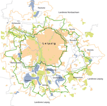
The Green Ring Leipzig (GRL) is a voluntary and equal cooperation between the cities and the surrounding area (not a special purpose association ) that brings together the 14 municipalities of Belgershain , Böhlen , Borsdorf , Brandis , Großpösna , Leipzig , Markkleeberg , Markranstädt , Pegau , Rackwitz , Rötha , Schkeuditz , Taucha and Zwenkau as well as the districts of Leipzig and Northern Saxony belong. Many regionally active organizations, associations, companies, citizens and clubs are involved in the projects. The Green Ring Leipzig was founded in 1996 to jointly improve the attractiveness of the region.
The City of Leipzig, represented by the Office for Urban Greenery and Waters, is responsible in the Green Ring Leipzig for: policy and strategic work, project management, acquisition of funding, budget and allocation management, implementation of the purpose agreement, management of the AG Gewässerverbund Leipziger Neuseenland and the representation of the municipalities to third parties.
The office of the Green Ring Leipzig in Borsdorf is responsible for: public relations, communication and organization, networking for all actors, terrain model Leipziger Neuseenland, construction and maintenance of the signage of the cycle route, the display boards, the route environment & nature and the maintenance of the water way signage.
course
The bike path Green ring Leipzig - cycling route (until 2020 called the Outer Green Ring) connects more than 165 km, the member municipalities of the CRL. It crosses other regional cycle routes such as the Elster Cycle Route , Elster-Saale Cycle Route, Parthe-Mulde Cycle Route, Pleiße Cycle Route and New Lake District Route. It begins in the northwest in the Elsteraue and Luppenaue and leads via Rackwitz to the Leipziger Messe , into the Parthenaue, via Naunhofer and Brandiser Forst and the Oberholz past the Leipziger Neuseenland to the Kulkwitzer See , then back towards Schkeuditz .
Until 2020 there was also an Inner Green Ring, which led over 65 km through the districts along Leipzig's city limits and through Markkleeberg and ran partly on independent cycle paths, partly on normal roads. Since the importance of the Inner Ring was assessed as minor and upgrading it was considered too costly, the signage was dismantled in May / June 2020.
Conception
The projects deal with the topics of the environment, water and landscape.
The Regional Action Concept (RHK) is intended to serve as a guideline for the environmentally compatible development of the cultural and landscape region and is a guideline and basis for action for the work of the Green Ring Leipzig. The first regional action plan was created in 1998, an update with 26 key projects and over 900 individual measures has been available since November 2003, followed by an interim assessment in 2006. Current projects of the Green Ring Leipzig as well as numerous studies and information are available to everyone on the GRL website.
Web links
- Website of Grüner Ring Leipzig
- Tourist water association Leipziger Neuseenland
- Green Ring Leipzig. In: Website of the city of Leipzig. Retrieved August 10, 2018 .
Individual evidence
- ↑ City of Pegau is now a member of the ring and an implementation management is needed for the tourism concept. In: Leipziger Internet Zeitung. March 23, 2015, accessed August 10, 2018 .
- ^ André Neumann: Rötha hopes for money for projects from the Green Ring. In: Leipziger Volkszeitung. May 13, 2018. Retrieved August 9, 2018 .
- ↑ Attention: Inner Green Ring is currently being dismantled. In: gruenerring-leipzig.de. May 19, 2020, accessed June 3, 2020 .
Coordinates: 51 ° 20 ′ 43.4 ″ N , 12 ° 31 ′ 54.5 ″ E


