Greenswag
Grünschwade was a customs and port on the western bank of the Peene river . The place belonged to the parish of Kröslin and was east of Freest / Freesendorf on the headland "Holm" near the island of Dänholm , opposite the Peenemünder Schanze . Because of constant flooding, the place was moved further inland.

history
For the first time Grünschwade was mentioned in 1580 in a customs roll of Duke Ernst Ludwig of Pomerania . A narrow branch of the Peene River south of the village served as a winter and emergency port. Because of the ideal location for the control of all ship movements between the Baltic Sea and the Stettiner Haff , there was a customs station here, where the prince's toll levied in Wolgast was collected.
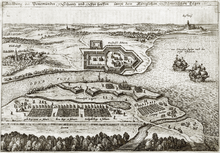
In 1630 the imperial family set up their own ski jump in Grünschwade opposite Gustav Adolf's ski jump in Peenemünde.
In the Swedish registers of 1694, the place Grünschwade is at the tip of the Holm peninsula, but it is only a single farm of the customs office.
The place Grünschwade was first mentioned as Grünsward in 1722.
The place retained its function as a customs office during the Swedish times. The Swedish Admiralty used the natural harbor as a military base and had it secured by a wooden barrier between the mainland and Dänholm. This divided the part of the port used by the military from the area open to merchant ships.
With the expansion of the port of Swinoujscie and the making of the Swine navigable in the middle of the 18th century and the associated decrease in shipping traffic on the Peene River, the town began to decline. During the Seven Years' War , the place was completely destroyed in the fighting for the Peenemünder Schanze on the opposite bank.
The emergency and winter harbor was still used and a harbor master was employed. During the French era , French soldiers were stationed here to monitor compliance with the continental barrier.
After the transition from Swedish Pomerania to Prussia , Greenschwade consisted of a single homestead in which a border guard lived with his family. This had to be announced to the passing ships. According to the Prussian original measuring table sheet, another farm was 100 m south of the border guard farm and was called Klein Grünschwade. With the demolition of the buildings in 1888, Grünschwade ceased to exist as a settlement. The bulwark was still used as a seaport in 1904.
literature
- Joachim Krüger : The customs, emergency and pilot port Grünschwade - a Swedish-Prussian problem area on the Peene river . In: Ivo Asmus, Heiko Droste, Jens E. Olesen (eds.): Common acquaintances. Sweden and Germany in the early modern period. Dedicated to Helmut Backhaus on the occasion of his 65th birthday. LIT Verlag, Berlin-Hamburg-Münster 2003, ISBN 978-3-8258-7150-5 , p. 307ff.
Individual evidence
- ^ Manfred Niemeyer: Ostvorpommern . Collection of sources and literature on place names. Vol. 2: Mainland. (= Greifswald contributions to toponymy. Vol. 2), Ernst-Moritz-Arndt University of Greifswald, Institute for Slavic Studies, Greifswald 2001, ISBN 3-86006-149-6 . P. 45
Web links
- Literature about green wad in the catalog of the state bibliography Mecklenburg-Western Pomerania
Coordinates: 54 ° 8 ′ 21.7 ″ N , 13 ° 44 ′ 56 ″ E
