Grüntensee
| Grüntensee | |||||||
|---|---|---|---|---|---|---|---|
|
|||||||
|
|
|||||||
| Coordinates | 47 ° 37 ′ 0 ″ N , 10 ° 27 ′ 0 ″ E | ||||||
| Data on the structure | |||||||
| Construction time: | 1961/62 | ||||||
| Height above foundation level : | 21 m | ||||||
| Building volume: | 130,000 m³ | ||||||
| Crown length: | 180 m | ||||||
| Power plant output: | 1.04 MW | ||||||
| Data on the reservoir | |||||||
| Altitude (at congestion destination ) | 876 m | ||||||
| Water surface | 123.4 ha | ||||||
| Reservoir length | 2.5 km | ||||||
| Total storage space : | 14.8 million m³ | ||||||
| Catchment area | 82.2 km² | ||||||
| Design flood : | 85 m³ / s | ||||||
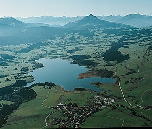
The Grüntensee is a 2.5 km long and 11.2 m deep reservoir of the Wertach with a circumference of 8.2 km in the Oberallgäu district on the border with the Ostallgäu district , Bavarian Swabia , Bavaria , 3.1 km west of Nesselwang . The reservoir was completed in 1962 and is used for flood protection and electricity generation. A power of 1 MW is generated in a hydropower plant .
The Grüntensee and some areas of its shore are also used as a recreational area. The Grüntensee climbing forest (a high ropes course) is located on the north shore of the Grüntensee .
The lake was named after the eye-catching mountain Grünten on the northern edge of the Allgäu Alps , about 11 kilometers southwest .
Others
- The east bank was the location for the TV film Klarer Fall für Bär, which was broadcast on ZDF in 2011, starring Hans Sigl .
See also
Web links
Commons : Grüntensee - Collection of images, videos and audio files
- Grüntensee - Information on the Grüntensee from the Bavarian State Office for the Environment


