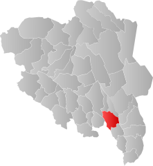
Stange (Norway)
| coat of arms | map | |
|---|---|---|

|
|
|
| Basic data | ||
| Commune number : | 3413 | |
| Province (county) : | Domestic | |
| Administrative headquarters: | pole | |
| Coordinates : | 60 ° 43 ' N , 11 ° 11' E | |
| Surface: | 724.27 km² | |
| Residents: | 21,064 (Feb 27, 2020) | |
| Population density : | 29 inhabitants per km² | |
| Language form : | Bokmål | |
| Postal code : | 2336 | |
| Website: | ||
| traffic | ||
| Railway connection: | Dovrebanen | |
| politics | ||
| Mayor : | Nils Amund Røhne ( Ap ) (2007) | |
| Located in the province of Innlandet | ||

|
||
is a place and amunicipalityinNorway, north ofOslo.
Larger settlements in the municipality are Ilseng, Ottestad, Stange, Romedal, Tangen and Vallset.
The highest point in the area is 641 m and is called Arekjølen .
Neighboring municipalities from Stange are: Eidsvoll ( Viken ), Hamar , Løten , Nord-Odal , Østre Toten and Våler .
The large secondary school for agriculture and industrial production of agricultural products is Jønsberg vidergående skole in Stange .
Attractions
West of Stange is a church called Stange, built in 1250. The Norsk Utvander Museum has existed since 1954 .
Personalities
- Johan Friedrich Schwabe (1749–1821), lawyer and inspector of Greenland
- Otto Albert Blehr (1847–1927), lawyer and liberal politician
- Holm Hansen Munthe (1848–1898), architect
- Odvar Nordli (1927–2018), politician
- Irene Dalby (* 1971), swimmer
- Kristian Tonning Riise (* 1988), politician
Web links
Commons : rod - album with pictures, videos and audio files

