
Dig long bridge
| Dig long bridge | ||
 The "ditch long bridge" during major changes |
||
| Data | ||
| location | south of Großwechselungen , Werther municipality , Nordhausen district , Thuringia , Germany | |
| River system | Elbe | |
| Drain over | Röstegraben → Helme → Unstrut → Saale → Elbe → North Sea | |
| source | several sources southwest of major changes 51 ° 28 ′ 47 ″ N , 10 ° 39 ′ 50 ″ E |
|
| Source height | 236 m | |
| muzzle | south of major changes in the Röstegraben Coordinates: 51 ° 29 ′ 8 ″ N , 10 ° 41 ′ 34 ″ E 51 ° 29 ′ 8 ″ N , 10 ° 41 ′ 34 ″ E |
|
| Mouth height | 197 m above sea level NN | |
| Height difference | 39 m | |
| Bottom slope | 15 ‰ | |
| length | from the northern source: 2.17 km; from the southern source about 2.7 km | |
| Communities | Werther | |
| Residents in the catchment area | 860 | |
The moat long bridge is a left tributary of the Röstegraben at Großwechselungen in the Nordhausen district in Thuringia.
course
The small brook rises from several sources southeast of Großwechselungen in an arable land. He crosses a dirt road and the street "long bridge", which gives him his name. After a good 2.7 km, the long bridge joins the Röstegraben and strengthens it before it reaches major changes.
photos
The moat long bridge crosses the street of the same name "long bridge"

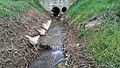
The moat long bridge (coming from the left) flows into the Röstegraben (right)


Web links
Commons : Dig Long Bridge - Collection of Pictures, Videos and Audio Files