Gray River (Tasman Sea)
| Gray River | ||
|
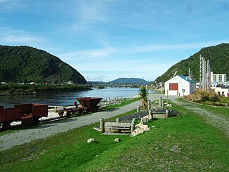
The Gray River at Greymouth, in the foreground the remains of the former coal harbor |
||
| Data | ||
| location | West Coast , South Island (New Zealand) | |
| River system | Gray River | |
| Source lake |
Lake Christabel 42 ° 24 ′ 29 ″ S , 172 ° 13 ′ 8 ″ E |
|
| muzzle | in Greymouth in the Tasman Sea Coordinates: 42 ° 26 '22 " S , 171 ° 11' 27" E 42 ° 26 '22 " S , 171 ° 11' 27" E
|
|
| length | 120 km | |
| Left tributaries | Ahaura River , Arnold River | |
| Small towns | Greymouth | |
The Gray River is a river on the South Island of New Zealand . It rises from Lake Christabel , one of the numerous lakes of the west coast region of the Southern Alps , 12 km south of the Lewis Pass and flows for a distance of 120 km westwards before it flows into the Tasman Sea in Greymouth .
The mouth of the Gray River is closed by a large sandbar, which is considered a hazard zone for navigation in the mouth.
The river was discovered by the explorer Thomas Brunner and named in honor of the New Zealand politician Sir George Gray . The Maori name of the river is Mawhera.
Web links
Commons : Gray River - Collection of images, videos and audio files
